IMAGES TAKEN NEAR TO
Linkinhorne, CALLINGTON, PL17 7NA
Introduction
This page details the photographs taken nearby to PL17 7NA by members of the Geograph project.
The Geograph project started in 2005 with the aim of publishing, organising and preserving representative images for every square kilometre of Great Britain, Ireland and the Isle of Man.

There are currently over 7.5m images from over14,400 individuals and you can help contribute to the project by visiting https://www.geograph.org.uk
Image Map
Images are licensed for reuse under creativecommons.org/licenses/by-sa/2.0
Notes
- Clicking on the map will re-center to the selected point.
- The higher the marker number, the further away the image location is from the centre of the postcode.
Image Listing (4 Images Found)
Images are licensed for reuse under creativecommons.org/licenses/by-sa/2.0
Image
Details
Distance
1
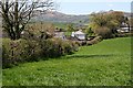
Houses along the road
The hills in the background are of Bodmin Moor
Image: © Tony Atkin
Taken: 18 Apr 2007
0.05 miles
2
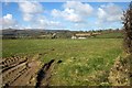
Field near Patrieda Barn
The settlement seen across field from the lane shown in Image
Image: © Derek Harper
Taken: 4 Mar 2015
0.14 miles
3
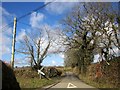
Crossroads near Patrieda Barn
With a particularly awry signpost.
Image: © Derek Harper
Taken: 4 Mar 2015
0.18 miles
4
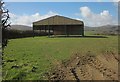
Barn near Patrieda Barn
A fairly recently-built barn, seen from the same point as Image], looking to the left. Caradon Hill is on the left.
Image: © Derek Harper
Taken: 4 Mar 2015
0.20 miles