IMAGES TAKEN NEAR TO
South Hill Road, CALLINGTON, PL17 7LQ
Introduction
This page details the photographs taken nearby to South Hill Road, PL17 7LQ by members of the Geograph project.
The Geograph project started in 2005 with the aim of publishing, organising and preserving representative images for every square kilometre of Great Britain, Ireland and the Isle of Man.

There are currently over 7.5m images from over14,400 individuals and you can help contribute to the project by visiting https://www.geograph.org.uk
Image Map
Images are licensed for reuse under creativecommons.org/licenses/by-sa/2.0
Notes
- Clicking on the map will re-center to the selected point.
- The higher the marker number, the further away the image location is from the centre of the postcode.
Image Listing (2 Images Found)
Images are licensed for reuse under creativecommons.org/licenses/by-sa/2.0
Image
Details
Distance
1
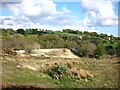
Site of Redmoor mine
A part of the extensive site which was once the Redmoor Mine.
The mine had more or less closed by the 1880s although sporadic reworking continued up to 1943.
But commercial interest in these old mines has not gone away. The Redmoor site has been the subject of recent investigation into whether there's anything worthwhile still here. http://nae.net.au/projects/united-kingdom/redmoor/
Image: © Des Blenkinsopp
Taken: 29 Apr 2015
0.18 miles