IMAGES TAKEN NEAR TO
CALLINGTON, PL17 7JY
Introduction
This page details the photographs taken nearby to PL17 7JY by members of the Geograph project.
The Geograph project started in 2005 with the aim of publishing, organising and preserving representative images for every square kilometre of Great Britain, Ireland and the Isle of Man.

There are currently over 7.5m images from over14,400 individuals and you can help contribute to the project by visiting https://www.geograph.org.uk
Image Map (Loading...)


Getting Data...Please wait
Leaflet Map data © OpenStreetMap
Images are licensed for reuse under creativecommons.org/licenses/by-sa/2.0
Notes
- Clicking on the map will re-center to the selected point.
- The higher the marker number, the further away the image location is from the centre of the postcode.
Image Listing (16 Images Found)
Images are licensed for reuse under creativecommons.org/licenses/by-sa/2.0
Image
Details
Distance
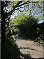
1
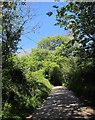
Lane at Lendra
Climbing from the Haye Valley Stream, a tributary of the Lynher.
Image: © Derek Harper
Taken: 14 May 2014
0.04 miles
2
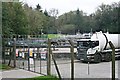
Callington Water Treatment Works
Situated down by the River Lynher near Lendra Wood.
Image: © Tony Atkin
Taken: 14 Oct 2006
0.06 miles
3
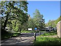
Callington Sewage Treatment Works
Image: © Derek Harper
Taken: 14 May 2014
0.07 miles
4
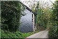
Converted building near Lendra Wood
This seems to be an example of an old barn or industrial buildings converted to residential use.
Image: © Tony Atkin
Taken: 14 Oct 2006
0.08 miles
5
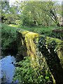
Bridge over Haye Valley Stream
The bridge from which Image] was taken, looking to the left.
Image: © Derek Harper
Taken: 14 May 2014
0.08 miles
6
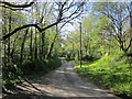
Lane past Callington Sewage Treatment Works
Buried deep in the Haye valley. Lendra Wood is on the left.
Image: © Derek Harper
Taken: 14 May 2014
0.09 miles
7
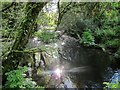
Haye Valley Stream
The tributary of the Lynher, seen looking downstream from the lane shown in Image] as it flows along the edge of Lendra Wood.
Image: © Derek Harper
Taken: 14 May 2014
0.09 miles
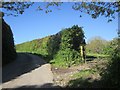
8
Lane near Caddapit House
Climbing from the bridge shown in Image
Image: © Derek Harper
Taken: 14 May 2014
0.13 miles
9
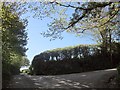
Lane junction, Caddapit
Just around the corner in Image The right turn is for Trevigro; straight on to Golberdon. The junction is shown from the other direction in Image
Image: © Derek Harper
Taken: 14 May 2014
0.13 miles
10
Lane to Trevigro
The scene just round the corner to the right in Image], with the lane passing a gateway.
Image: © Derek Harper
Taken: 14 May 2014
0.13 miles