IMAGES TAKEN NEAR TO
Newbridge, CALLINGTON, PL17 7HL
Introduction
This page details the photographs taken nearby to PL17 7HL by members of the Geograph project.
The Geograph project started in 2005 with the aim of publishing, organising and preserving representative images for every square kilometre of Great Britain, Ireland and the Isle of Man.

There are currently over 7.5m images from over14,400 individuals and you can help contribute to the project by visiting https://www.geograph.org.uk
Image Map
Images are licensed for reuse under creativecommons.org/licenses/by-sa/2.0
Notes
- Clicking on the map will re-center to the selected point.
- The higher the marker number, the further away the image location is from the centre of the postcode.
Image Listing (54 Images Found)
Images are licensed for reuse under creativecommons.org/licenses/by-sa/2.0
Image
Details
Distance
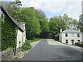
1
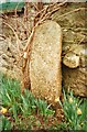
Old Boundary Marker
County Bridge Marker set in stone wall outside Cobbledick's Cottage on the east side of Newbridge Road 25 metres north of Newbridge, River Lynher. Callington parish. Inscribed C. The stone marks the extent of roadway adjoining the bridge that the County was obliged to maintain.
Milestone Society National ID: CW_CALL06br
Image: © R Hanns
Taken: 12 Nov 2019
0.03 miles
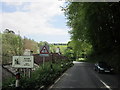
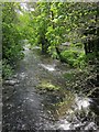
2
River Lynher
Looking downstream from the lane between Newbridge and Cadson Bury.
Image: © Derek Harper
Taken: 14 May 2014
0.03 miles
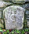
3
Old Guide Stone by Cobbledick's Cottage, Newbridge
By the UC road, in parish of Callington (Caradon District), Newbridge, Southeast of bridge, by Cobbledick's Cottage, against wall of cottage.
Grade II listed.
List Entry Number: 1140080 https://historicengland.org.uk/listing/the-list/list-entry/1140080
Surveyed
Milestone Society National ID: CW_XCALL
Image: © Milestone Society
Taken: Unknown
0.03 miles
4
Old Guide Stone near the A390 at Newbridge
Guide Stone by the UC road, in parish of Callington (Caradon District), Newbridge, Southeast of bridge, by Cobbledick's Cottage, against wall of cottage, North side of road.
Inscription reads:-
WHEEL
ROAD
TO
CALLᴺ
Grade II listed.
List Entry Number: 1140080 https://historicengland.org.uk/listing/the-list/list-entry/1140080
Surveyed
Milestone Society National ID: CW_XCALL
Image: © Rosy Hanns
Taken: 10 May 2019
0.04 miles
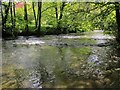
5
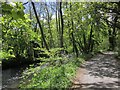
Lane by the Lynher
The lane between Newbridge and the car park shown in Image
Image: © Derek Harper
Taken: 14 May 2014
0.05 miles
6
River Lynher
Looking downstream from the bridge shown in Image
Image: © Derek Harper
Taken: 14 May 2014
0.05 miles
7
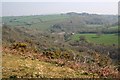
Newbridge from Cadson Bury Fort
Looking north from the hilltop, Newbridge is the dotting of houses in the Lynher Valley trees at the centre of the scene.
Image: © Tony Atkin
Taken: 21 Apr 2007
0.06 miles
8
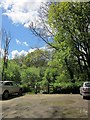
Car park, Newbridge
The National Trust car park for Cadson Bury, although most users seem to be sticking to the lovely wooded riverside walk along the Lynher rather than climbing the hillfort.
Image: © Derek Harper
Taken: 14 May 2014
0.06 miles