IMAGES TAKEN NEAR TO
Redmore Court, CALLINGTON, PL17 7FW
Introduction
This page details the photographs taken nearby to Redmore Court, PL17 7FW by members of the Geograph project.
The Geograph project started in 2005 with the aim of publishing, organising and preserving representative images for every square kilometre of Great Britain, Ireland and the Isle of Man.

There are currently over 7.5m images from over14,400 individuals and you can help contribute to the project by visiting https://www.geograph.org.uk
Image Map
Images are licensed for reuse under creativecommons.org/licenses/by-sa/2.0
Notes
- Clicking on the map will re-center to the selected point.
- The higher the marker number, the further away the image location is from the centre of the postcode.
Image Listing (11 Images Found)
Images are licensed for reuse under creativecommons.org/licenses/by-sa/2.0
Image
Details
Distance
1
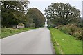
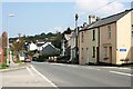
The Straight Road
This is South Hill Road, looking towards Callington. When you see a straight stretch of road in this part of the country you have to wonder why it is straight.
Image: © Tony Atkin
Taken: 14 Oct 2006
0.03 miles
2
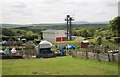
Fire Station behind the Allotments
Looking from the Callington to Launceston road at the fire station. In front are allotments.
Image: © roger geach
Taken: 18 May 2010
0.06 miles
3
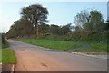
South Mill Road
A view of the road shown in Image, looking in the other direction, with darkness falling. Taken almost opposite Image
Image: © Derek Harper
Taken: 1 Nov 2011
0.06 miles
4
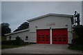
Callington Fire Station
Callington Fire Station, South Hill Road, Callington, Cornwall. This replaces the old fire station in Haye Road. Image
Image: © Kevin Hale
Taken: 26 Sep 2004
0.08 miles
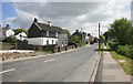
5
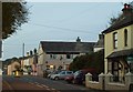
The Road to Kelly Bray
On the northern outskirts of Callington looking along the road to Kelly Bray just a mile away. This road is actually called Launceston Road and, unsurprisingly, goes to Launceston eventually. Just in front of the building in the right foreground is the bottom of Florence Hill.
Image: © Tony Atkin
Taken: 20 Apr 2009
0.14 miles
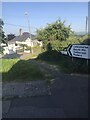
7
Looking towards Kelly Bray
The Callington to Launceston road
Image: © roger geach
Taken: 18 May 2010
0.15 miles
8
Outskirts of Callington
The view towards Callington from the Kelly Bray road. There is some house building taking place on the left in front of these houses.
Image: © roger geach
Taken: 18 May 2010
0.15 miles
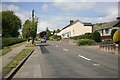
9
Launceston Road, Callington
The A388 passing through the northern outskirts of the town, seen as darkness falls.
Image: © Derek Harper
Taken: 1 Nov 2011
0.17 miles
10
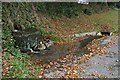
Stone Water Trough
The stream fills this trough before spilling over into a roadside culvert on South Hill Road. Presumably the trough was put there for the benefit of horses.
Image: © Tony Atkin
Taken: 14 Oct 2006
0.21 miles