IMAGES TAKEN NEAR TO
Broadwoodwidger, LIFTON, PL16 0ET
Introduction
This page details the photographs taken nearby to PL16 0ET by members of the Geograph project.
The Geograph project started in 2005 with the aim of publishing, organising and preserving representative images for every square kilometre of Great Britain, Ireland and the Isle of Man.

There are currently over 7.5m images from over14,400 individuals and you can help contribute to the project by visiting https://www.geograph.org.uk
Image Map
Images are licensed for reuse under creativecommons.org/licenses/by-sa/2.0
Notes
- Clicking on the map will re-center to the selected point.
- The higher the marker number, the further away the image location is from the centre of the postcode.
Image Listing (3 Images Found)
Images are licensed for reuse under creativecommons.org/licenses/by-sa/2.0
Image
Details
Distance
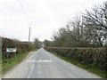
2
November Lane
Looking along the road between Grinacombe Moor and Grinacombe Cross.
Image: © Tony Atkin
Taken: 13 Nov 2010
0.06 miles
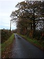
3
Grinacombe Moor
A road hamlet north of Broadwoodwidger. The left turn heads towards several farms and the Roadford Reservoir.
Image: © Derek Harper
Taken: 23 Sep 2006
0.06 miles