IMAGES TAKEN NEAR TO
South Hill, PLYMOUTH, PL1 5RR
Introduction
This page details the photographs taken nearby to South Hill, PL1 5RR by members of the Geograph project.
The Geograph project started in 2005 with the aim of publishing, organising and preserving representative images for every square kilometre of Great Britain, Ireland and the Isle of Man.

There are currently over 7.5m images from over14,400 individuals and you can help contribute to the project by visiting https://www.geograph.org.uk
Image Map (Loading...)


Getting Data...Please wait
Leaflet Map data © OpenStreetMap
Images are licensed for reuse under creativecommons.org/licenses/by-sa/2.0
Notes
- Clicking on the map will re-center to the selected point.
- The higher the marker number, the further away the image location is from the centre of the postcode.
Image Listing (130 Images Found)
Images are licensed for reuse under creativecommons.org/licenses/by-sa/2.0
Image
Details
Distance
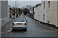
2
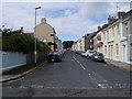
Waterloo Street
From Providence Place looking up Waterloo Street
Image: © Shaun Ferguson
Taken: 7 Aug 2010
0.05 miles
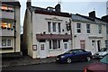
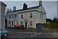
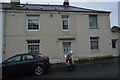
6

Formerly The Stoke Vaults
Now a private residence.
Image: © N Chadwick
Taken: 7 Jan 2017
0.07 miles
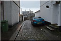
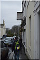
7
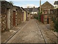
Back alley, Devonport
The alley serves the rear of properties in Waterloo Street (left) and Paradise Road (right)
Image: © Derek Harper
Taken: 17 Jul 2008
0.08 miles