IMAGES TAKEN NEAR TO
Devonport Road, PLYMOUTH, PL1 5RF
Introduction
This page details the photographs taken nearby to Devonport Road, PL1 5RF by members of the Geograph project.
The Geograph project started in 2005 with the aim of publishing, organising and preserving representative images for every square kilometre of Great Britain, Ireland and the Isle of Man.

There are currently over 7.5m images from over14,400 individuals and you can help contribute to the project by visiting https://www.geograph.org.uk
Image Map
Images are licensed for reuse under creativecommons.org/licenses/by-sa/2.0
Notes
- Clicking on the map will re-center to the selected point.
- The higher the marker number, the further away the image location is from the centre of the postcode.
Image Listing (193 Images Found)
Images are licensed for reuse under creativecommons.org/licenses/by-sa/2.0
Image
Details
Distance
8
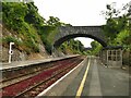
Devonport station with bridges
The photo shows that the station is situated in a cutting. The nearer bridge carries Havelock Terrace, and the further one Devonport Road.
Image: © Stephen Craven
Taken: 27 Jun 2023
0.07 miles
9
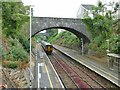
Local train from Devonport towards Plymouth
Great Western Railway's Sorinter unit 150239 departs at 20.25 near the end of its journey down the Tamar Valley from Gunnislake.
Image: © Stephen Craven
Taken: 30 Jun 2023
0.07 miles