IMAGES TAKEN NEAR TO
Cecil Street, PLYMOUTH, PL1 5HL
Introduction
This page details the photographs taken nearby to Cecil Street, PL1 5HL by members of the Geograph project.
The Geograph project started in 2005 with the aim of publishing, organising and preserving representative images for every square kilometre of Great Britain, Ireland and the Isle of Man.

There are currently over 7.5m images from over14,400 individuals and you can help contribute to the project by visiting https://www.geograph.org.uk
Image Map (Loading...)


Getting Data...Please wait
Leaflet Map data © OpenStreetMap
Images are licensed for reuse under creativecommons.org/licenses/by-sa/2.0
Notes
- Clicking on the map will re-center to the selected point.
- The higher the marker number, the further away the image location is from the centre of the postcode.
Image Listing (499 Images Found)
Images are licensed for reuse under creativecommons.org/licenses/by-sa/2.0
Image
Details
Distance
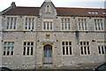
7
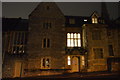
St Boniface School
Grade II listed. http://www.britishlistedbuildings.co.uk/101130016-st-boniface-school-st-peter-and-the-waterfront-ward
Image: © N Chadwick
Taken: 7 Jan 2017
0.07 miles
8
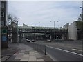
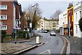
Pedestrian bridge linking the multi-storey carpark to the shopping area
Image: © Sarah Charlesworth
Taken: 23 May 2009
0.07 miles
10
St Boniface School
Grade II listed. https://www.britishlistedbuildings.co.uk/101130016-st-boniface-school-st-peter-and-the-waterfront-ward
Image: © N Chadwick
Taken: 3 Dec 2017
0.07 miles