IMAGES TAKEN NEAR TO
Arundel Crescent, PLYMOUTH, PL1 5FD
Introduction
This page details the photographs taken nearby to Arundel Crescent, PL1 5FD by members of the Geograph project.
The Geograph project started in 2005 with the aim of publishing, organising and preserving representative images for every square kilometre of Great Britain, Ireland and the Isle of Man.

There are currently over 7.5m images from over14,400 individuals and you can help contribute to the project by visiting https://www.geograph.org.uk
Image Map
Images are licensed for reuse under creativecommons.org/licenses/by-sa/2.0
Notes
- Clicking on the map will re-center to the selected point.
- The higher the marker number, the further away the image location is from the centre of the postcode.
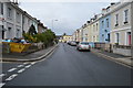
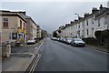
Image Listing (225 Images Found)
Images are licensed for reuse under creativecommons.org/licenses/by-sa/2.0
Image
Details
Distance
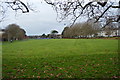
1
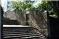
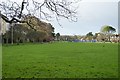
Steps from Victoria Park, Plymouth
Or to it, if you're lucky enough to be descending them. They lead to North Road West. But it was the wall that caught my eye.
Image: © Derek Harper
Taken: 8 Aug 2015
0.04 miles
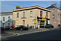
10
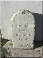
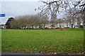
Old Boundary Marker on Cecil Street, Plymouth
Water Boundary Marker on the west side of Cecil Street, Plymouth, against the side wall of "Cornerstone" beside a gate. It is inscribed STONEHOUSE / LEAT / AND BANKS / 1593 but dates from the 1850’s.
Milestone Society National ID: DV_SLBB03em
Image: © T Jenkinson
Taken: 26 Feb 2008
0.05 miles