IMAGES TAKEN NEAR TO
St. Giles-on-the-Heath, LAUNCESTON, PL15 9RU
Introduction
This page details the photographs taken nearby to PL15 9RU by members of the Geograph project.
The Geograph project started in 2005 with the aim of publishing, organising and preserving representative images for every square kilometre of Great Britain, Ireland and the Isle of Man.

There are currently over 7.5m images from over14,400 individuals and you can help contribute to the project by visiting https://www.geograph.org.uk
Image Map (Loading...)


Getting Data...Please wait
Leaflet Map data © OpenStreetMap
Images are licensed for reuse under creativecommons.org/licenses/by-sa/2.0
Notes
- Clicking on the map will re-center to the selected point.
- The higher the marker number, the further away the image location is from the centre of the postcode.
Image Listing (6 Images Found)
Images are licensed for reuse under creativecommons.org/licenses/by-sa/2.0
Image
Details
Distance
1
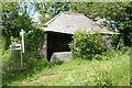
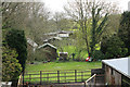
Broadwoodwidger: des res
Old barn at Downicary, about to be re-developed? Looking north east by the turning to Coombe Mill and Emsworthy
Image: © Martin Bodman
Taken: 28 May 2007
0.06 miles
2
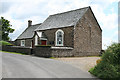
Broadwoodwidger: Downicary Methodist Church
Looking south west
Image: © Martin Bodman
Taken: 28 May 2007
0.08 miles
3
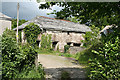
Broadwoodwidger: by Tower Hill farm
An old farm building. Looking north east
Image: © Martin Bodman
Taken: 28 May 2007
0.23 miles
4
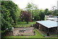
Broadwoodwidger: Tower Hill
The site of the former station, built by the London & South West Railway, on the line to Wadebridge and Padstow, now a smallholding. It was 218 miles from London Waterloo. The route became known by cynics as the ‘Withered Arm’, but in 1943 this station had extra sidings constructed to serve ammunition dumps in the hinterland for the United States military
Image: © Martin Bodman
Taken: 28 May 2007
0.24 miles
5
Once the Railway to Padstow
This was the site of the former LSWR North Cornwall station of Tower Hill. There is nothing left of the former station at all apart from the Station Cottages. Closed 01October 1966
Image: © roger geach
Taken: 1 May 2012
0.24 miles
6
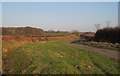
Lane east of Downicary
A wide verge and ditch at a bend on the lane to Upcott Cross. In the distance is Beech Hill Farm. On the left is Grove Plantation.
Image: © Derek Harper
Taken: 8 Feb 2012
0.25 miles