IMAGES TAKEN NEAR TO
Underlane, LAUNCESTON, PL15 9RR
Introduction
This page details the photographs taken nearby to Underlane, PL15 9RR by members of the Geograph project.
The Geograph project started in 2005 with the aim of publishing, organising and preserving representative images for every square kilometre of Great Britain, Ireland and the Isle of Man.

There are currently over 7.5m images from over14,400 individuals and you can help contribute to the project by visiting https://www.geograph.org.uk
Image Map
Images are licensed for reuse under creativecommons.org/licenses/by-sa/2.0
Notes
- Clicking on the map will re-center to the selected point.
- The higher the marker number, the further away the image location is from the centre of the postcode.
Image Listing (7 Images Found)
Images are licensed for reuse under creativecommons.org/licenses/by-sa/2.0
Image
Details
Distance
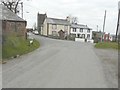
1
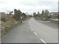
Looking along Underlane
Towards the church tower of Holy Name.
Image: © John Baker
Taken: 29 Mar 2013
0.02 miles
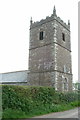
2
Looking along Underlane
With the church tower of Holy Name on the right.
Image: © John Baker
Taken: 29 Mar 2013
0.06 miles
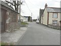
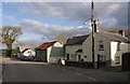
4
Cottages at Boyton
Looking across a crossroads of gridlines at this road junction on the east side of the village. On the left, a few metres along Underlane, is the Church of the Holy Name. Braggs Hill, to the right, leads down into the Tamar valley.
Image: © Derek Harper
Taken: 6 Nov 2007
0.09 miles
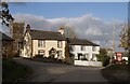
5
The road through Boyton
With the name-plate for Underhill (the road to the left) on the grass verge and the church tower of Holy Name beyond.
Image: © John Baker
Taken: 29 Mar 2013
0.09 miles
6
Scene in Boyton
Detailed maps suggest that the left-hand part of the cream building was, until recently, a Post Office. Taken from opposite the Methodist Church; the road ahead leads to the Parish Church.
Image: © Derek Harper
Taken: 6 Nov 2007
0.15 miles
7
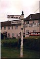
Old Direction Sign - Signpost in Boyton
Pyramid spear finial - 3 arms; Cornwall CC iron spear by the UC road, in parish of Boyton (North Cornwall District), in front of terraced houses, on verge, West side of road.
Cornwall & Scilly HER.
HER Number: MCO57744 https://www.heritagegateway.org.uk/Gateway/Results_Single.aspx?uid=MCO57744&resourceID=1020
Surveyed
Milestone Society National ID: CW_SX3191
Image: © Milestone Society
Taken: Unknown
0.24 miles