IMAGES TAKEN NEAR TO
LAUNCESTON, PL15 9QY
Introduction
This page details the photographs taken nearby to PL15 9QY by members of the Geograph project.
The Geograph project started in 2005 with the aim of publishing, organising and preserving representative images for every square kilometre of Great Britain, Ireland and the Isle of Man.

There are currently over 7.5m images from over14,400 individuals and you can help contribute to the project by visiting https://www.geograph.org.uk
Image Map (Loading...)


Getting Data...Please wait
Leaflet Map data © OpenStreetMap
Images are licensed for reuse under creativecommons.org/licenses/by-sa/2.0
Notes
- Clicking on the map will re-center to the selected point.
- The higher the marker number, the further away the image location is from the centre of the postcode.
Image Listing (7 Images Found)
Images are licensed for reuse under creativecommons.org/licenses/by-sa/2.0
Image
Details
Distance
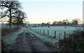
1
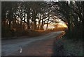
Sunrise at Coleman's Cross
The first light of a frosty day reaches the junction shown from the other direction at Image On the left is Raddons Plantation.
Image: © Derek Harper
Taken: 19 Jan 2017
0.13 miles
2
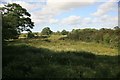
Pasture Land by Heale bridge
Pasture land as seen from the gateway by Heale bridge.
Image: © roger geach
Taken: 5 Jul 2010
0.15 miles
3
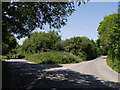
Coleman's Cross
To the right, a fairly busy road from Liftondown to join the A388 to Holsworthy; left also joins the A388 at Netherbridge.
Image: © Derek Harper
Taken: 7 Jun 2007
0.17 miles
4
Sunrise by Coleman's Cross
From beside where Image was taken, looking towards Launceston on a frosty morning.
Image: © Derek Harper
Taken: 19 Jan 2017
0.22 miles
5
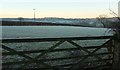
Farm track to Tettaridge Barton
Leading away from the rather busy road that links the A30 and the A388 across Heale Bridge. Just about dawn on a cold and frosty morning.
Image: © Derek Harper
Taken: 19 Jan 2017
0.23 miles
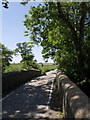
6

Heale Bridge
A bit of a bottleneck on this well-used lane linking the A388 at Tipple Cross to Liftondown, avoiding Launceston. The River Carey passes under this end of the lengthy bridge, having run beside it on the left for 50 metres.
Image: © Derek Harper
Taken: 7 Jun 2007
0.24 miles
7
Heale Bridge
A reverse view of Image The single-track stretch of road straddles a gridline. Beyond on the left are fields around Tettaridge.
Image: © Derek Harper
Taken: 7 Jun 2007
0.24 miles