IMAGES TAKEN NEAR TO
Polson Bridge, LAUNCESTON, PL15 9QU
Introduction
This page details the photographs taken nearby to PL15 9QU by members of the Geograph project.
The Geograph project started in 2005 with the aim of publishing, organising and preserving representative images for every square kilometre of Great Britain, Ireland and the Isle of Man.

There are currently over 7.5m images from over14,400 individuals and you can help contribute to the project by visiting https://www.geograph.org.uk
Image Map (Loading...)


Getting Data...Please wait
Leaflet Map data © OpenStreetMap
Images are licensed for reuse under creativecommons.org/licenses/by-sa/2.0
Notes
- Clicking on the map will re-center to the selected point.
- The higher the marker number, the further away the image location is from the centre of the postcode.
Image Listing (15 Images Found)
Images are licensed for reuse under creativecommons.org/licenses/by-sa/2.0
Image
Details
Distance
1
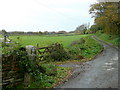
Track to Welltown Farm
First or last farm in Devon, depending on your direction of travel.
Image: © Jonathan Billinger
Taken: 18 Nov 2009
0.13 miles
2
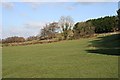
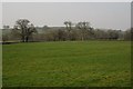
Pasture near Welltown Farm
The land here is just rising gently out of the Tamar flood plain.
Image: © Tony Atkin
Taken: 3 Feb 2007
0.13 miles
3
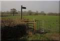
Two Castles Trail at Polson
The Two Castles Trail follows Lifton Footpath 10 through this gate into a field on the Tamar flood plain beside the track shown in Image
Image: © Derek Harper
Taken: 2 Mar 2012
0.14 miles
4
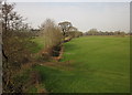
Tamar flood plain near Polson Bridge
From the A388 just east of the bridge. 20 metres beyond the central oak, the drain crosses into Image
Image: © Derek Harper
Taken: 2 Mar 2012
0.17 miles
5
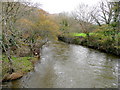
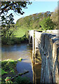
River Tamar - downstream
The Cornwall-Devon border viewed from Polson Bridge.
Image: © Jonathan Billinger
Taken: 18 Nov 2009
0.17 miles
6
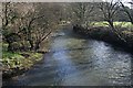
The River Tamar
Looking downstream from Polson Bridge
Image: © Tony Atkin
Taken: 3 Feb 2007
0.18 miles
7

Polson Bridge
The downstream side of the bridge over the Tamar; see Image for the history. Linking two counties and therefore two parishes as it does, it gets two listed building descriptions at http://www.britishlistedbuildings.co.uk/en-92367-polson-bridge-lifton and http://www.britishlistedbuildings.co.uk/en-68403-polson-bridge-that-part-in-lawhitton-rura , the latter being more detailed.
Image: © Derek Harper
Taken: 2 Mar 2012
0.18 miles
8
Trees on the Tamar flood plain
A view across a meadow from the Two Castles Trail as it follows Lifton Footpath 10. The trees on the left are along the drainage ditch shown in Image
Image: © Derek Harper
Taken: 2 Mar 2012
0.19 miles
9
Polson Bridge over the River Tamar
This photo is taken from the Cornwall side of the river looking into Devon on the other bank. The Tamar forms almost the whole length of the boundary between the two counties.
Image: © Rod Allday
Taken: 26 Oct 2011
0.19 miles
10
Polson Bridge over the Tamar
The upstream side of the bridge, looking from Cornwall over to Devon.
A similar picture is Image showing the downstream side from the Devon bank.
Image: © Des Blenkinsopp
Taken: 26 May 2021
0.19 miles