IMAGES TAKEN NEAR TO
Trebullett, LAUNCESTON, PL15 9QQ
Introduction
This page details the photographs taken nearby to PL15 9QQ by members of the Geograph project.
The Geograph project started in 2005 with the aim of publishing, organising and preserving representative images for every square kilometre of Great Britain, Ireland and the Isle of Man.

There are currently over 7.5m images from over14,400 individuals and you can help contribute to the project by visiting https://www.geograph.org.uk
Image Map (Loading...)


Getting Data...Please wait
Leaflet Map data © OpenStreetMap
Images are licensed for reuse under creativecommons.org/licenses/by-sa/2.0
Notes
- Clicking on the map will re-center to the selected point.
- The higher the marker number, the further away the image location is from the centre of the postcode.
Image Listing (1 Images Found)
Images are licensed for reuse under creativecommons.org/licenses/by-sa/2.0
Image
Details
Distance
1
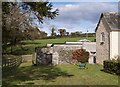
Wheelbarrow at Lower Larrick
"So much depends upon..." This one is turquoise and yellow, but there is a blaze of red (cotoneaster berries?) behind it. The farmhouse on the right crosses a gridline, but the bit you can see is in SX3078. The trees at the top of the field are along the lane between Higher Larrick and Trebullett. Taken from footpath 524/13/1.
Image: © Derek Harper
Taken: 18 Oct 2007
0.05 miles