IMAGES TAKEN NEAR TO
Lezant, LAUNCESTON, PL15 9PT
Introduction
This page details the photographs taken nearby to PL15 9PT by members of the Geograph project.
The Geograph project started in 2005 with the aim of publishing, organising and preserving representative images for every square kilometre of Great Britain, Ireland and the Isle of Man.

There are currently over 7.5m images from over14,400 individuals and you can help contribute to the project by visiting https://www.geograph.org.uk
Image Map (Loading...)


Getting Data...Please wait
Leaflet Map data © OpenStreetMap
Images are licensed for reuse under creativecommons.org/licenses/by-sa/2.0
Notes
- Clicking on the map will re-center to the selected point.
- The higher the marker number, the further away the image location is from the centre of the postcode.
Image Listing (8 Images Found)
Images are licensed for reuse under creativecommons.org/licenses/by-sa/2.0
Image
Details
Distance
1

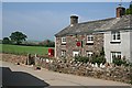
A post office no longer, Penscombe Cross
See Image The post office closed in 2008, to be "replaced by an outreach service". No use if I happen to drop by equipped with a slightly old map. Even the postbox has gone.
Image: © Derek Harper
Taken: 14 Apr 2015
0.01 miles
2
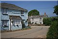
Trekenner Post Office
The post office is situated at Penscombe Cross which has just four houses on the crossroads. It is about a kilometre from Trekenner village and about half a kilometre from Lezant village.
Image: © Tony Atkin
Taken: 5 May 2007
0.01 miles
3
Penscombe Cross
Just a few houses on a countryside road junction.
Image: © Tony Atkin
Taken: 5 May 2007
0.01 miles
5
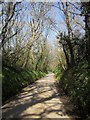
Lane to Penscombe Cross
A tree-lined lane between banks.
Image: © Derek Harper
Taken: 14 Apr 2015
0.13 miles
6

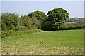
Field near Lezant
From the lane from Penscombe Cross. The valley is a tributary of the Lowley Brook.
Image: © Derek Harper
Taken: 14 Apr 2015
0.17 miles
7
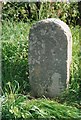
Old Milestone by the A388, south of Penscombe Farm
Carved stone post by the A388, in parish of LEZANT (NORTH CORNWALL District), just South of Pencombe Farm, on the verge on bend, on East side of road. Lanson stone pillar, erected by the Launceston turnpike trust in the 19th century.
Inscription reads:-
LANSON
4
MILE
CALL
6½
MILE
Grade II Listed. List Entry Number: 1291435
https://historicengland.org.uk/listing/the-list/list-entry/1291435
Milestone Society National ID: CW_LACL04.
Image: © Ian Thompson
Taken: 1 May 2005
0.25 miles
8
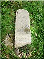
Old Milestone, broken by the A388, near Penscombe Farm
Carved stone post by the A388, in parish of LEZANT (NORTH CORNWALL District), just South of Penscombe Farm, on the verge on bend, on East side of road. Lanson stone pillar, erected by the Launceston turnpike trust in the 19th century.
Inscription reads:-
LANDSON
4
MILE
CALL
6½
MILE
(To Launceston and Callington)
Grade II listed.
List Entry Number: 1291435 https://historicengland.org.uk/listing/the-list/list-entry/1291435
Milestone Society National ID: CW_LACL04.
Image: © Rosy Hanns
Taken: 29 Mar 2019
0.25 miles