IMAGES TAKEN NEAR TO
Lezant, LAUNCESTON, PL15 9PR
Introduction
This page details the photographs taken nearby to PL15 9PR by members of the Geograph project.
The Geograph project started in 2005 with the aim of publishing, organising and preserving representative images for every square kilometre of Great Britain, Ireland and the Isle of Man.

There are currently over 7.5m images from over14,400 individuals and you can help contribute to the project by visiting https://www.geograph.org.uk
Image Map (Loading...)


Getting Data...Please wait
Leaflet Map data © OpenStreetMap
Images are licensed for reuse under creativecommons.org/licenses/by-sa/2.0
Notes
- Clicking on the map will re-center to the selected point.
- The higher the marker number, the further away the image location is from the centre of the postcode.
Image Listing (8 Images Found)
Images are licensed for reuse under creativecommons.org/licenses/by-sa/2.0
Image
Details
Distance
1
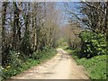
Lane to Lezant
At the right bend the lane crosses a small tributary of the Lowley Brook. It then passes the village sign for Lezant, though the village is still a little way ahead.
Image: © Derek Harper
Taken: 14 Apr 2015
0.11 miles
2
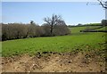
Scene near Lezant
From the same spot as Image] (the trees on the left are along the stream mentioned), looking to the right.
Image: © Derek Harper
Taken: 14 Apr 2015
0.21 miles
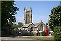
3
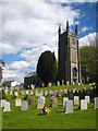
The Church of St Briochus in Lezant
A Grade II Listed parish church dating from the C13th and restored in 1869.
Image: © Rod Allday
Taken: 13 May 2012
0.23 miles
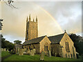
5
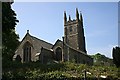
Lezant Church
The church of Lezant parish is dedicated to St Michael but was originally dedicated to St Briocus in 1259. In common with most Cornish parish churches it was extensively restored in the late 19th century.
Image: © Tony Atkin
Taken: 5 May 2007
0.24 miles
7
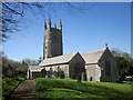
Church of St Briocus, Lezant
Similar in direction to Image (which includes a listed telephone box http://list.historicengland.org.uk/resultsingle.aspx?uid=1290726&searchtype=mapsearch ) but from within the churchyard. The grade II* listed church, originally C13, is described at http://list.historicengland.org.uk/resultsingle.aspx?uid=1291277&searchtype=mapsearch.
Image: © Derek Harper
Taken: 14 Apr 2015
0.24 miles
8
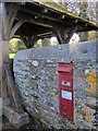
Postbox, Lezant
Victorian postbox PL15 38 is in the churchyard wall beside the lychgate, although the number is not visible on the plate.
Image: © Derek Harper
Taken: 14 Apr 2015
0.25 miles