IMAGES TAKEN NEAR TO
St. Michaels Close, LAUNCESTON, PL15 9NF
Introduction
This page details the photographs taken nearby to St. Michaels Close, PL15 9NF by members of the Geograph project.
The Geograph project started in 2005 with the aim of publishing, organising and preserving representative images for every square kilometre of Great Britain, Ireland and the Isle of Man.

There are currently over 7.5m images from over14,400 individuals and you can help contribute to the project by visiting https://www.geograph.org.uk
Image Map (Loading...)


Getting Data...Please wait
Leaflet Map data © OpenStreetMap
Images are licensed for reuse under creativecommons.org/licenses/by-sa/2.0
Notes
- Clicking on the map will re-center to the selected point.
- The higher the marker number, the further away the image location is from the centre of the postcode.
Image Listing (9 Images Found)
Images are licensed for reuse under creativecommons.org/licenses/by-sa/2.0
Image
Details
Distance
2
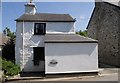
Old Post Office, Lawhitton
The cottage is a few yards up the hill from the church.
Image: © Derek Harper
Taken: 7 Jun 2007
0.05 miles
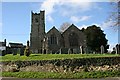
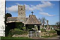
3
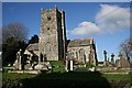
Lawhitton Church
This church dates from the 13th century and is dedicated to St Michael. Unusually the tower is on the south side of the church.
Image: © Tony Atkin
Taken: 3 Feb 2007
0.05 miles
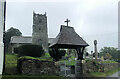
5
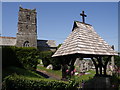
St Michael's church, Lawhitton
A rather similar view to Image The unbuttressed tower lessens in height in stages without continuous tapering. Cornish crosses can be seen through the lych gate.
Image: © Derek Harper
Taken: 7 Jun 2007
0.06 miles
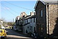
8
Houses in Lawhitton
Beyond the houses is a view of the Tamar Valley.
Image: © Tony Atkin
Taken: 3 Feb 2007
0.11 miles
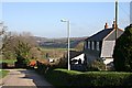
9
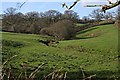
Valley east of Lawhitton
Like most good villages, Lawhitton is situated near to a water course but above the valley bottom and out of the way of flooding.
Image: © Tony Atkin
Taken: 3 Feb 2007
0.20 miles