IMAGES TAKEN NEAR TO
Blackbird Crescent, LAUNCESTON, PL15 9LW
Introduction
This page details the photographs taken nearby to Blackbird Crescent, PL15 9LW by members of the Geograph project.
The Geograph project started in 2005 with the aim of publishing, organising and preserving representative images for every square kilometre of Great Britain, Ireland and the Isle of Man.

There are currently over 7.5m images from over14,400 individuals and you can help contribute to the project by visiting https://www.geograph.org.uk
Image Map (Loading...)


Getting Data...Please wait
Leaflet Map data © OpenStreetMap
Images are licensed for reuse under creativecommons.org/licenses/by-sa/2.0
Notes
- Clicking on the map will re-center to the selected point.
- The higher the marker number, the further away the image location is from the centre of the postcode.
Image Listing (6 Images Found)
Images are licensed for reuse under creativecommons.org/licenses/by-sa/2.0
Image
Details
Distance
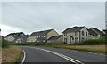
2
New housing on the edge of Launceston
A new development called "Tamar Vista". No matter how hard I looked I could not see any vista of the River Tamar or its valley from the vicinity.
Image: © Tony Atkin
Taken: 3 Feb 2007
0.11 miles
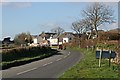
3

Modern Housing at Stourscombe
Typical suburban bungalow housing and an old country lane on the edge of Launceston. Another hamlet becomes part of the town.
Image: © Tony Atkin
Taken: 3 Feb 2007
0.18 miles
4
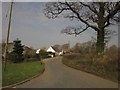
Modern housing at Stourscombe
A scene which has changed little since Image was taken, though one conifer has grown a lot while another has been trimmed. On the right is an oak tree.
Image: © Derek Harper
Taken: 2 Mar 2012
0.19 miles
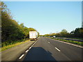
6
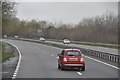
North Cornwall : The A30
The A30 heading through the former North Cornwall district.
Image: © Lewis Clarke
Taken: 23 Feb 2014
0.24 miles