IMAGES TAKEN NEAR TO
LAUNCESTON, PL15 9LP
Introduction
This page details the photographs taken nearby to PL15 9LP by members of the Geograph project.
The Geograph project started in 2005 with the aim of publishing, organising and preserving representative images for every square kilometre of Great Britain, Ireland and the Isle of Man.

There are currently over 7.5m images from over14,400 individuals and you can help contribute to the project by visiting https://www.geograph.org.uk
Image Map (Loading...)


Getting Data...Please wait
Leaflet Map data © OpenStreetMap
Images are licensed for reuse under creativecommons.org/licenses/by-sa/2.0
Notes
- Clicking on the map will re-center to the selected point.
- The higher the marker number, the further away the image location is from the centre of the postcode.
Image Listing (4 Images Found)
Images are licensed for reuse under creativecommons.org/licenses/by-sa/2.0
Image
Details
Distance
1
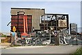
Ex Flour Mill
This flour mill on the southern outskirts of Launceston is in the process of demolition.
Image: © Tony Atkin
Taken: 5 May 2007
0.15 miles
3
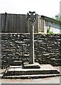
Dunheved Cross
This old stone cross is at what used to be the end of Dunheved Road and, I believe, something of a local landmark but its site is now an out of the way back lane as Dunheved Road has been truncated by the huge cutting of the A30 dual carriageway.
Image: © Tony Atkin
Taken: 5 May 2007
0.23 miles
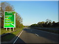
4
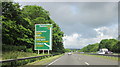
A30 Westbound Pennygillam Junction For Launceston
Image: © Roy Hughes
Taken: 23 Jun 2012
0.24 miles