IMAGES TAKEN NEAR TO
Cherry Way, LAUNCESTON, PL15 9GR
Introduction
This page details the photographs taken nearby to Cherry Way, PL15 9GR by members of the Geograph project.
The Geograph project started in 2005 with the aim of publishing, organising and preserving representative images for every square kilometre of Great Britain, Ireland and the Isle of Man.

There are currently over 7.5m images from over14,400 individuals and you can help contribute to the project by visiting https://www.geograph.org.uk
Image Map (Loading...)


Getting Data...Please wait
Leaflet Map data © OpenStreetMap
Images are licensed for reuse under creativecommons.org/licenses/by-sa/2.0
Notes
- Clicking on the map will re-center to the selected point.
- The higher the marker number, the further away the image location is from the centre of the postcode.
Image Listing (7 Images Found)
Images are licensed for reuse under creativecommons.org/licenses/by-sa/2.0
Image
Details
Distance
1
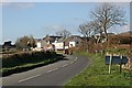
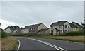
New housing on the edge of Launceston
A new development called "Tamar Vista". No matter how hard I looked I could not see any vista of the River Tamar or its valley from the vicinity.
Image: © Tony Atkin
Taken: 3 Feb 2007
0.15 miles
3
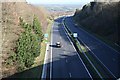
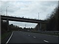
The A30 at Launceston
With the railway now long gone, this is Launceston's gateway to the rest of the world.
Image: © Tony Atkin
Taken: 3 Feb 2007
0.21 miles
4
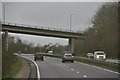
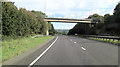
North Cornwall : The A30
The A30 heading through North Cornwall near Launceston.
Image: © Lewis Clarke
Taken: 23 Feb 2014
0.22 miles
5
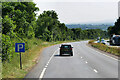
Layby on the A30 eastbound near Launceston
Image: © David Dixon
Taken: 7 Jun 2023
0.22 miles