IMAGES TAKEN NEAR TO
LAUNCESTON, PL15 9GL
Introduction
This page details the photographs taken nearby to PL15 9GL by members of the Geograph project.
The Geograph project started in 2005 with the aim of publishing, organising and preserving representative images for every square kilometre of Great Britain, Ireland and the Isle of Man.

There are currently over 7.5m images from over14,400 individuals and you can help contribute to the project by visiting https://www.geograph.org.uk
Image Map (Loading...)


Getting Data...Please wait
Leaflet Map data © OpenStreetMap
Images are licensed for reuse under creativecommons.org/licenses/by-sa/2.0
Notes
- Clicking on the map will re-center to the selected point.
- The higher the marker number, the further away the image location is from the centre of the postcode.
Image Listing (5 Images Found)
Images are licensed for reuse under creativecommons.org/licenses/by-sa/2.0
Image
Details
Distance
1
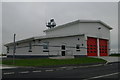
Launceston Fire Station
Launceston Fire Station, Hurdon Road, Launceston, Cornwall. It was built to replace the previous station in Westgate Street. Image
Image: © Kevin Hale
Taken: 26 Sep 2004
0.06 miles
2
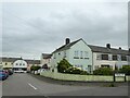
Housing estate on Hurdon Road, Launceston
Image: © David Smith
Taken: 6 Jul 2021
0.14 miles
3
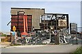
Ex Flour Mill
This flour mill on the southern outskirts of Launceston is in the process of demolition.
Image: © Tony Atkin
Taken: 5 May 2007
0.15 miles
5

Hurdon Farm
The farmhouse is late Victorian but looks older http://www.imagesofengland.org.uk/Details/Default.aspx?id=370011&mode=adv . The buildings on the left are listed separately http://www.imagesofengland.org.uk/Details/Default.aspx?id=370012&mode=adv . Behind are the valley of the Lowley Brook, and Landlake Wood, in Image
Image: © Derek Harper
Taken: 26 Feb 2010
0.24 miles