IMAGES TAKEN NEAR TO
Cornflower Close, LAUNCESTON, PL15 9GA
Introduction
This page details the photographs taken nearby to Cornflower Close, PL15 9GA by members of the Geograph project.
The Geograph project started in 2005 with the aim of publishing, organising and preserving representative images for every square kilometre of Great Britain, Ireland and the Isle of Man.

There are currently over 7.5m images from over14,400 individuals and you can help contribute to the project by visiting https://www.geograph.org.uk
Image Map (Loading...)


Getting Data...Please wait
Leaflet Map data © OpenStreetMap
Images are licensed for reuse under creativecommons.org/licenses/by-sa/2.0
Notes
- Clicking on the map will re-center to the selected point.
- The higher the marker number, the further away the image location is from the centre of the postcode.
Image Listing (6 Images Found)
Images are licensed for reuse under creativecommons.org/licenses/by-sa/2.0
Image
Details
Distance
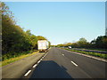
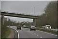
2
North Cornwall : The A30
The A30 heading through the former North Cornwall district.
Image: © Lewis Clarke
Taken: 23 Feb 2014
0.06 miles
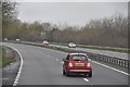
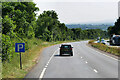
3
Lay-by on A30 westbound east of Launceston
This lay-by does not have any protection from traffic on the main road; several of the small lay-bys on the A30 have a small kerb between the carriageway and the parking area. Possibly, because this one is on an uphill slope, it was deemed unnecessary.
Image: © David Smith
Taken: 6 Mar 2012
0.09 miles
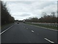
4
North Cornwall : The A30
The A30 heading through North Cornwall near Launceston.
Image: © Lewis Clarke
Taken: 23 Feb 2014
0.20 miles
5
Layby on the A30 eastbound near Launceston
Image: © David Dixon
Taken: 7 Jun 2023
0.21 miles