IMAGES TAKEN NEAR TO
Holborn Terrace, LAUNCESTON, PL15 9ES
Introduction
This page details the photographs taken nearby to Holborn Terrace, PL15 9ES by members of the Geograph project.
The Geograph project started in 2005 with the aim of publishing, organising and preserving representative images for every square kilometre of Great Britain, Ireland and the Isle of Man.

There are currently over 7.5m images from over14,400 individuals and you can help contribute to the project by visiting https://www.geograph.org.uk
Image Map
Images are licensed for reuse under creativecommons.org/licenses/by-sa/2.0
Notes
- Clicking on the map will re-center to the selected point.
- The higher the marker number, the further away the image location is from the centre of the postcode.
Image Listing (6 Images Found)
Images are licensed for reuse under creativecommons.org/licenses/by-sa/2.0
Image
Details
Distance
2
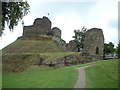
Launceston Castle
Situated at the western edge of the gridsquare this is a classic motte and bailey ruin.
Image: © Chris Shaw
Taken: Unknown
0.16 miles
3
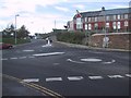
Double mini-roundabouts at Page's Cross
Image: © Sarah Charlesworth
Taken: 1 Nov 2008
0.21 miles
5
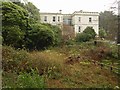
Craigmore, Launceston
The apparently unlisted mansion sits on Windmill Hill to the south of the town centre.
Image: © Derek Harper
Taken: 23 Nov 2009
0.24 miles
6
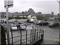
The small car park in Southgate Street Launceston
The short stay car park in Southgate Street Launceston.
Image: © Eric Foster
Taken: 11 Nov 2011
0.24 miles