IMAGES TAKEN NEAR TO
Warbstow, Canworthy Water, LAUNCESTON, PL15 8UU
Introduction
This page details the photographs taken nearby to PL15 8UU by members of the Geograph project.
The Geograph project started in 2005 with the aim of publishing, organising and preserving representative images for every square kilometre of Great Britain, Ireland and the Isle of Man.

There are currently over 7.5m images from over14,400 individuals and you can help contribute to the project by visiting https://www.geograph.org.uk
Image Map (Loading...)


Getting Data...Please wait
Leaflet Map data © OpenStreetMap
Images are licensed for reuse under creativecommons.org/licenses/by-sa/2.0
Notes
- Clicking on the map will re-center to the selected point.
- The higher the marker number, the further away the image location is from the centre of the postcode.
Image Listing (7 Images Found)
Images are licensed for reuse under creativecommons.org/licenses/by-sa/2.0
Image
Details
Distance
1
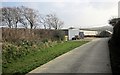
Approaching Hendra
Footpath 561 1/2 follows this concrete track past the farm.
Image: © Derek Harper
Taken: 18 Mar 2015
0.04 miles
2
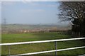
Farmland, Hendra
A view from footpath 561 1/2 near the farm, looking towards the Ottery valley.
Image: © Derek Harper
Taken: 18 Mar 2015
0.06 miles
3
Footpath near Hendra
Footpath 561 1/2 follows the concrete track from the farm to the lane.
Image: © Derek Harper
Taken: 18 Mar 2015
0.08 miles
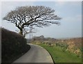
4
Trees by the lane to Hendra Farm
The farm lane is followed by footpath 561 1/2.
Image: © Derek Harper
Taken: 18 Mar 2015
0.13 miles
5
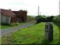
Hendra Farm
One of two entrances to Hendra and the farm, warning lorries to use the other.
Image: © Neil Lewin
Taken: 8 Jul 2006
0.23 miles
6
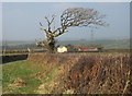
Tree by Hendra Cottage
No prizes for guessing which way the prevailing winds blow around here. Hendra Cottage is just down the road to Langdon.
Image: © Derek Harper
Taken: 18 Mar 2015
0.23 miles
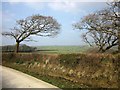
7
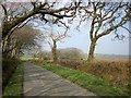
Lane to Langdon
This lane, followed by NCN 3, cuts across the southeast corner of the square.
Image: © Derek Harper
Taken: 18 Mar 2015
0.24 miles