IMAGES TAKEN NEAR TO
Canworthy Water, LAUNCESTON, PL15 8UB
Introduction
This page details the photographs taken nearby to PL15 8UB by members of the Geograph project.
The Geograph project started in 2005 with the aim of publishing, organising and preserving representative images for every square kilometre of Great Britain, Ireland and the Isle of Man.

There are currently over 7.5m images from over14,400 individuals and you can help contribute to the project by visiting https://www.geograph.org.uk
Image Map (Loading...)


Getting Data...Please wait
Leaflet Map data © OpenStreetMap
Images are licensed for reuse under creativecommons.org/licenses/by-sa/2.0
Notes
- Clicking on the map will re-center to the selected point.
- The higher the marker number, the further away the image location is from the centre of the postcode.
Image Listing (4 Images Found)
Images are licensed for reuse under creativecommons.org/licenses/by-sa/2.0
Image
Details
Distance
1
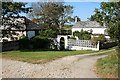
Warbstow: by Canworthy House
Canworthy House stands in a small settlement off the beaten track which includes converted barns and a farm
Image: © Martin Bodman
Taken: 15 Sep 2007
0.06 miles
2
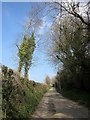
Lane to Canworthy
The no through lane from Canworthy Water climbs from the Ottery valley towards the hamlet.
Image: © Derek Harper
Taken: 18 Mar 2015
0.09 miles
3

Farm lane to Witheven
From beside the gateway where Image] was taken - not a right of way.
Image: © Derek Harper
Taken: 18 Mar 2015
0.19 miles
4
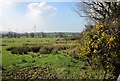
Farmland near Canworthy
By the farm track to Witheven, looking across the valley of the River Ottery.
Image: © Derek Harper
Taken: 18 Mar 2015
0.22 miles