IMAGES TAKEN NEAR TO
Warbstow Cross, LAUNCESTON, PL15 8TZ
Introduction
This page details the photographs taken nearby to Warbstow Cross, PL15 8TZ by members of the Geograph project.
The Geograph project started in 2005 with the aim of publishing, organising and preserving representative images for every square kilometre of Great Britain, Ireland and the Isle of Man.

There are currently over 7.5m images from over14,400 individuals and you can help contribute to the project by visiting https://www.geograph.org.uk
Image Map
Images are licensed for reuse under creativecommons.org/licenses/by-sa/2.0
Notes
- Clicking on the map will re-center to the selected point.
- The higher the marker number, the further away the image location is from the centre of the postcode.
Image Listing (8 Images Found)
Images are licensed for reuse under creativecommons.org/licenses/by-sa/2.0
Image
Details
Distance
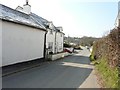
2
Village street, Warbstow Cross
The main street passing Warbstow Community Primary School on the left.
Image: © Derek Harper
Taken: 18 Mar 2015
0.03 miles
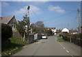
3
Road junction at Warbstow Cross
The road to the left takes one to Warbstow church while that straight on ends at Hallworthy in Image on the A395.
Image: © John Baker
Taken: 28 Mar 2013
0.08 miles
4
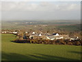
Warbstow Cross houses from Warbstow Bury
View from the eastern rampart of Warbstow Bury, looking along the road towards Canworthy Water. There are many more houses at Warbstow Cross than in Warbstow itself.
Image: © David Hawgood
Taken: 26 Feb 2008
0.09 miles
5
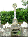
Warbstow Cross
Monument to the fallen of both World Wars. Warbstow Cross was mentioned in the Domesday Book as Werburghstow meaning land dedicated to St Werburgha
Image: © Neil Lewin
Taken: 10 Jul 2006
0.11 miles
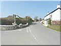
6
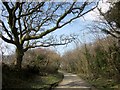
Lane to Warbstow Cross
From the north corner of the green at Downinney, with a belt of trees on the right.
Image: © Derek Harper
Taken: 18 Mar 2015
0.22 miles
7
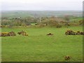
View from Warbstow Bury towards Warbstow
Image: © Andy Carlson
Taken: 28 Apr 2005
0.23 miles
8
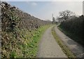
Lane to Treswen
Footpath 561 3/1 follows this farm lane to Treswen, and then cuts left across country towards Trebreak.
Image: © Derek Harper
Taken: 18 Mar 2015
0.24 miles