IMAGES TAKEN NEAR TO
Well Meadow, LAUNCESTON, PL15 8SS
Introduction
This page details the photographs taken nearby to Well Meadow, PL15 8SS by members of the Geograph project.
The Geograph project started in 2005 with the aim of publishing, organising and preserving representative images for every square kilometre of Great Britain, Ireland and the Isle of Man.

There are currently over 7.5m images from over14,400 individuals and you can help contribute to the project by visiting https://www.geograph.org.uk
Image Map
Images are licensed for reuse under creativecommons.org/licenses/by-sa/2.0
Notes
- Clicking on the map will re-center to the selected point.
- The higher the marker number, the further away the image location is from the centre of the postcode.
Image Listing (18 Images Found)
Images are licensed for reuse under creativecommons.org/licenses/by-sa/2.0
Image
Details
Distance
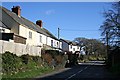
2
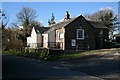
Egloskerry
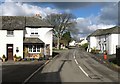
The name of this village, Egloskerry, means 'the church of Keri'. Eglos means 'church' in Cornish. This photo shows some houses at the centre of the village and the south porch of the church.
Image: © Tony Atkin
Taken: 25 Jan 2007
0.06 miles
3
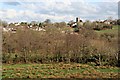
Egloskerry and the River Kensey Valley
Looking across the river valley to the village of Egloskerry.
Image: © Tony Atkin
Taken: 25 Jan 2007
0.09 miles
4
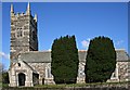
Egloskerry Parish Church
This church has a long history which goes back to at least 1260. It is dedicated to St Petrock and St Keri.
Image: © Tony Atkin
Taken: 25 Jan 2007
0.09 miles
5
Egloskerry
Rather a pretty village, with the houses in the centre being at angles to the road, and broken up by attractive spaces. The tree on the green is where the lane down into the Kensey valley turns off.
Image: © Derek Harper
Taken: 4 Mar 2008
0.09 miles

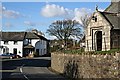
8
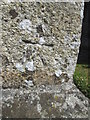
Ordnance Survey Cut Mark
This OS cut mark can be found on the porch of the Church of St Corantius. It marks a point 130.403m above mean sea level.
Image: © Adrian Dust
Taken: 20 Apr 2015
0.11 miles
9
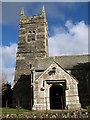
St Petrock's church, Egloskerry
Another view of Image A number of Norman features survive; the tower is C15 and of different rock from the granite porch.
Image: © Derek Harper
Taken: 4 Mar 2008
0.12 miles
10
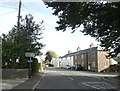
Houses on the eastern side of Egloskerry
Image: © Tony Atkin
Taken: 25 Jan 2007
0.12 miles