IMAGES TAKEN NEAR TO
Egloskerry, LAUNCESTON, PL15 8RY
Introduction
This page details the photographs taken nearby to PL15 8RY by members of the Geograph project.
The Geograph project started in 2005 with the aim of publishing, organising and preserving representative images for every square kilometre of Great Britain, Ireland and the Isle of Man.

There are currently over 7.5m images from over14,400 individuals and you can help contribute to the project by visiting https://www.geograph.org.uk
Image Map (Loading...)


Getting Data...Please wait
Leaflet Map data © OpenStreetMap
Images are licensed for reuse under creativecommons.org/licenses/by-sa/2.0
Notes
- Clicking on the map will re-center to the selected point.
- The higher the marker number, the further away the image location is from the centre of the postcode.
Image Listing (11 Images Found)
Images are licensed for reuse under creativecommons.org/licenses/by-sa/2.0
Image
Details
Distance
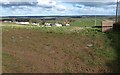
2
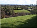
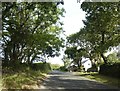
Kensey valley
A view to the right of Image, looking down the valley from the same spot, with a corner of Tor Wood on the left. The buildings on the right, set into the north side of the valley, are at Treburrow. The former Bude-Launceston railway line ran along the valley.
Image: © Derek Harper
Taken: 4 Mar 2008
0.14 miles
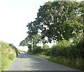
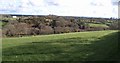
3
Road to Tresmeer
Image: © Derek Harper
Taken: 4 Mar 2008
0.14 miles
4
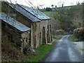
Barn at Treburrow
The barn, with strong buttresses, retains a slate roof. The view down the lane to the River Kensey constitutes a reverse view of Image
Image: © Derek Harper
Taken: 4 Mar 2008
0.14 miles
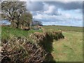
5
Houses at Tor Wood
The Victorian OS map labels this group as Tor Cottages
Image: © David Smith
Taken: 7 Sep 2020
0.17 miles
6
Kensey valley
Image: © Derek Harper
Taken: 4 Mar 2008
0.18 miles
7
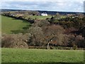
Kensey valley
The Kensey has quite a steep valley at this point. Tor Wood is both the name of the open woodland on the right, occupying the steep slopes, and of the white house on the hill. The former Bude-Launceston railway line ran at the foot of the slope. Seen from the lane from Tregeare to Treburrow.
Image: © Derek Harper
Taken: 4 Mar 2008
0.18 miles
8
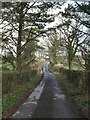
Lane at Treburrow
The lane shown in Image crosses the Kensey valley and climbs towards Treburrow and the lane from Tresmeer to Egloskerry.
Image: © Derek Harper
Taken: 4 Mar 2008
0.19 miles
9
Trebeath
The hamlet seen from the junction of the lane that leads to it with Image
Image: © Derek Harper
Taken: 4 Mar 2008
0.20 miles
10
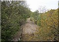
Former North Cornwall Railway
Looking west from the road overbridge one can see more of the trackbed in place now used as farm access.
Image: © roger geach
Taken: 18 May 2010
0.20 miles