IMAGES TAKEN NEAR TO
Tresmeer, LAUNCESTON, PL15 8QY
Introduction
This page details the photographs taken nearby to PL15 8QY by members of the Geograph project.
The Geograph project started in 2005 with the aim of publishing, organising and preserving representative images for every square kilometre of Great Britain, Ireland and the Isle of Man.

There are currently over 7.5m images from over14,400 individuals and you can help contribute to the project by visiting https://www.geograph.org.uk
Image Map
Images are licensed for reuse under creativecommons.org/licenses/by-sa/2.0
Notes
- Clicking on the map will re-center to the selected point.
- The higher the marker number, the further away the image location is from the centre of the postcode.
Image Listing (2 Images Found)
Images are licensed for reuse under creativecommons.org/licenses/by-sa/2.0
Image
Details
Distance
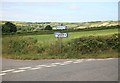
1
North Cornwall railway Tresmeer
The view off the road bridge looking towards Launceston. The former railway cutting is very overgrown since the closure of the line October 1966.
Image: © roger geach
Taken: 5 Jul 2010
0.21 miles