IMAGES TAKEN NEAR TO
St. Clether, LAUNCESTON, PL15 8QW
Introduction
This page details the photographs taken nearby to PL15 8QW by members of the Geograph project.
The Geograph project started in 2005 with the aim of publishing, organising and preserving representative images for every square kilometre of Great Britain, Ireland and the Isle of Man.

There are currently over 7.5m images from over14,400 individuals and you can help contribute to the project by visiting https://www.geograph.org.uk
Image Map (Loading...)


Getting Data...Please wait
Leaflet Map data © OpenStreetMap
Images are licensed for reuse under creativecommons.org/licenses/by-sa/2.0
Notes
- Clicking on the map will re-center to the selected point.
- The higher the marker number, the further away the image location is from the centre of the postcode.
Image Listing (4 Images Found)
Images are licensed for reuse under creativecommons.org/licenses/by-sa/2.0
Image
Details
Distance
1
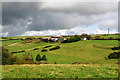
St Clether: Tregulland
The farm overlooks a tributary of the river Inny, from which it once derived water-power. A waterwheel on a leat in the valley powered machinery in Tregulland barns via long-drive transmission rods. A newer source of power now stands on the horizon
Image: © Martin Bodman
Taken: 28 Mar 2002
0.07 miles
2
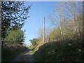
Lane to Tregulland
A little further up the steep lane shown in Image
Image: © Derek Harper
Taken: 20 Apr 2015
0.18 miles
3
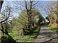
Lane to Tregulland
Climbing steeply from the River Inny, with youngish woodland on the left.
Image: © Derek Harper
Taken: 20 Apr 2015
0.23 miles
4
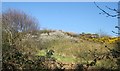
Hillside, Tregulland
On the east side of the lane shown in Image, a glimpse of gorse and blackthorn on the northern slopes of the Inny valley.
Image: © Derek Harper
Taken: 20 Apr 2015
0.25 miles