IMAGES TAKEN NEAR TO
St. Clether, LAUNCESTON, PL15 8QJ
Introduction
This page details the photographs taken nearby to PL15 8QJ by members of the Geograph project.
The Geograph project started in 2005 with the aim of publishing, organising and preserving representative images for every square kilometre of Great Britain, Ireland and the Isle of Man.

There are currently over 7.5m images from over14,400 individuals and you can help contribute to the project by visiting https://www.geograph.org.uk
Image Map
Images are licensed for reuse under creativecommons.org/licenses/by-sa/2.0
Notes
- Clicking on the map will re-center to the selected point.
- The higher the marker number, the further away the image location is from the centre of the postcode.
Image Listing (21 Images Found)
Images are licensed for reuse under creativecommons.org/licenses/by-sa/2.0
Image
Details
Distance
1
The River Inny at St Clether
Adjacent to the ancient Basill Manor.
Image: © Rod Allday
Taken: 6 Aug 2010
0.11 miles
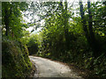
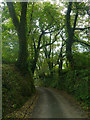
2
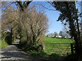
Lane at St Clether
By the lane junction at the former school. The lane leads up to the main part of the village, residentially speaking; the church and vicarage are up another hill behind the camera.
Image: © Derek Harper
Taken: 20 Apr 2015
0.11 miles
3
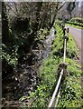
Laneside stream, St Clether
A tiny stream accompanies the lane from the junction mentioned in Image] down to the River Lynher - no more than 130 metres away.
Image: © Derek Harper
Taken: 20 Apr 2015
0.11 miles
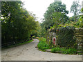
6
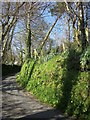
Lane at St Clether
The bank is sprinkled with spring flowers - primroses, daffodils, bluebells and dandelions. The lane leads from the school house to the church and vicarage.
Image: © Derek Harper
Taken: 20 Apr 2015
0.16 miles
7
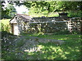
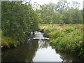
Hydro-electric generator at Basil Manor.
This generates enough power for the estate, and also enough surplus to the Electricity Generating Board.
Image: © Michael Murray
Taken: 2 Jun 2009
0.16 miles
9
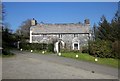
The Old Vicarage, St Clether
The C17 former vicarage, opposite the church, is described at http://list.historicengland.org.uk/resultsingle.aspx?uid=1142770&searchtype=mapsearch . "Hung with rag slates on front elevation".
Image: © Derek Harper
Taken: 20 Apr 2015
0.17 miles
10
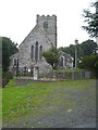
The parish church of St Clederus at St Clether
St Clederus was one of the twenty-four children of Saint Brychan, a Welsh saint and King of Brycheiniog in the 5th century.
Image: © Rod Allday
Taken: 6 Aug 2010
0.18 miles