IMAGES TAKEN NEAR TO
St. Clether, LAUNCESTON, PL15 8PX
Introduction
This page details the photographs taken nearby to PL15 8PX by members of the Geograph project.
The Geograph project started in 2005 with the aim of publishing, organising and preserving representative images for every square kilometre of Great Britain, Ireland and the Isle of Man.

There are currently over 7.5m images from over14,400 individuals and you can help contribute to the project by visiting https://www.geograph.org.uk
Image Map (Loading...)


Getting Data...Please wait
Leaflet Map data © OpenStreetMap
Images are licensed for reuse under creativecommons.org/licenses/by-sa/2.0
Notes
- Clicking on the map will re-center to the selected point.
- The higher the marker number, the further away the image location is from the centre of the postcode.
Image Listing (4 Images Found)
Images are licensed for reuse under creativecommons.org/licenses/by-sa/2.0
Image
Details
Distance
1
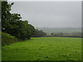
Pasture at Treboy Farm
On a wet and miserable August day.
Image: © Rod Allday
Taken: 6 Aug 2010
0.11 miles
2
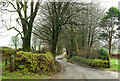
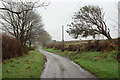
Lane past Treboy
Treboy and Treboy farm are just off to the right. A large puddle awaits just along the lane.
Image: © Derek Harper
Taken: 29 Jan 2018
0.15 miles
3
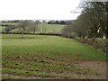
Field near Treboy Farm
At the foot of this field is a spring where a small tributary of the Inny rises. The shapes of the trees show the influence of the prevailing westerlies.
Image: © Derek Harper
Taken: 21 Feb 2008
0.18 miles