IMAGES TAKEN NEAR TO
North Petherwin, LAUNCESTON, PL15 8LR
Introduction
This page details the photographs taken nearby to PL15 8LR by members of the Geograph project.
The Geograph project started in 2005 with the aim of publishing, organising and preserving representative images for every square kilometre of Great Britain, Ireland and the Isle of Man.

There are currently over 7.5m images from over14,400 individuals and you can help contribute to the project by visiting https://www.geograph.org.uk
Image Map (Loading...)


Getting Data...Please wait
Leaflet Map data © OpenStreetMap
Images are licensed for reuse under creativecommons.org/licenses/by-sa/2.0
Notes
- Clicking on the map will re-center to the selected point.
- The higher the marker number, the further away the image location is from the centre of the postcode.
Image Listing (7 Images Found)
Images are licensed for reuse under creativecommons.org/licenses/by-sa/2.0
Image
Details
Distance
1
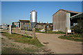
North Petherwin: Glebe Farm
Looking north east to farm buildings
Image: © Martin Bodman
Taken: 5 Oct 2007
0.05 miles
2
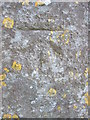
Ordnance Survey Cut Mark
This OS cut mark can be found on the NW angle of the Church of St Paternus. It marls a point 133.800m above mean sea level. http://www.geograph.org.uk/photo/4450575
Image: © Adrian Dust
Taken: 20 Apr 2015
0.11 miles
3
Church of St Paternus
There is an OS cut mark on the NW angle. http://www.geograph.org.uk/photo/4450572
Image: © Adrian Dust
Taken: 20 Apr 2015
0.12 miles
4
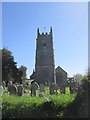
St Paternus Church
St Paternus Church North Petherwin
Image: © Shaun Ferguson
Taken: 27 Oct 2017
0.12 miles
5
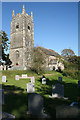
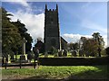
North Petherwin: St Padern?s church
Looking north east. Three-stage tower with angled buttresses; embattled, with pinnacles
Image: © Martin Bodman
Taken: 5 Oct 2007
0.14 miles
6
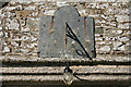
North Petherwin: sundial
Mounted on the south porch of St Padern’s church, dated 1821
Image: © Martin Bodman
Taken: 5 Oct 2007
0.14 miles
7
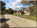
Parish Hall
North Petherwin Parish Hall on the edge of the village
Image: © Shaun Ferguson
Taken: 27 Oct 2017
0.23 miles