IMAGES TAKEN NEAR TO
Bolventor, LAUNCESTON, PL15 7TW
Introduction
This page details the photographs taken nearby to PL15 7TW by members of the Geograph project.
The Geograph project started in 2005 with the aim of publishing, organising and preserving representative images for every square kilometre of Great Britain, Ireland and the Isle of Man.

There are currently over 7.5m images from over14,400 individuals and you can help contribute to the project by visiting https://www.geograph.org.uk
Image Map (Loading...)


Getting Data...Please wait
Leaflet Map data © OpenStreetMap
Images are licensed for reuse under creativecommons.org/licenses/by-sa/2.0
Notes
- Clicking on the map will re-center to the selected point.
- The higher the marker number, the further away the image location is from the centre of the postcode.
Image Listing (7 Images Found)
Images are licensed for reuse under creativecommons.org/licenses/by-sa/2.0
Image
Details
Distance
1
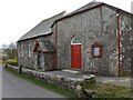
Chapel, St Lukes
The Bible Christian Chapel was built in 1891. The two parts of the building form an L-shape. Perhaps one part was the Sunday School?
They stand beside the lane from Bolventor to Trekeivesteps, which continues to the left into the view shown in Image
Image: © Derek Harper
Taken: 28 Feb 2008
0.03 miles
2
St Lukes Bible Christian Chapel
The slate plaque over the porch reads in Gothic script,'BCC 1891'.
Image: © Rod Allday
Taken: 27 Sep 2009
0.03 miles
3
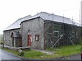
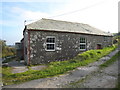
St. Luke's Chapel Bolventor
The chapel, now closed for worship, has been sold and planning application made for conversion into private dwelling.
Image: © Eric Foster
Taken: 15 Jun 2012
0.03 miles
4
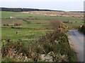
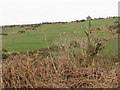
Fowey valley near St Luke's
The lane past Dryworks descends towards the valley - it will later run right beside the river for several kilometres. Old field boundaries are on the lower slopes.
The left-hand of the corrugated iron barns on the far side is a metre into Image Above it are conifer woods on Smith's Moor.
Image: © Derek Harper
Taken: 28 Feb 2008
0.05 miles
5
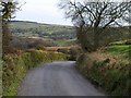
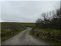
Lane at St Luke's
The lane from Bolventor to Trekeivesteps drops down to run beside the River Fowey. The former farm among the trees in the distance is Littleworth, now a holiday home, in Image
Image: © Derek Harper
Taken: 28 Feb 2008
0.09 miles