IMAGES TAKEN NEAR TO
North Hill, LAUNCESTON, PL15 7PE
Introduction
This page details the photographs taken nearby to PL15 7PE by members of the Geograph project.
The Geograph project started in 2005 with the aim of publishing, organising and preserving representative images for every square kilometre of Great Britain, Ireland and the Isle of Man.

There are currently over 7.5m images from over14,400 individuals and you can help contribute to the project by visiting https://www.geograph.org.uk
Image Map (Loading...)


Getting Data...Please wait
Leaflet Map data © OpenStreetMap
Images are licensed for reuse under creativecommons.org/licenses/by-sa/2.0
Notes
- Clicking on the map will re-center to the selected point.
- The higher the marker number, the further away the image location is from the centre of the postcode.
Image Listing (6 Images Found)
Images are licensed for reuse under creativecommons.org/licenses/by-sa/2.0
Image
Details
Distance
2
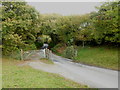
Cattle grid on the edge of the common at North Bowda
To prevent from straying stock which wander freely on the common.
Image: © Rod Allday
Taken: 30 Oct 2016
0.10 miles
3
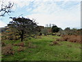
Moorland near North Bowda
The no through lane from Tresellern crosses a last stretch of access moorland before descending to Stonaford.
Image: © Derek Harper
Taken: 14 Apr 2015
0.13 miles
4
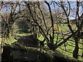
Track south-west of Stonaford
A private track, obstructed in the foreground, leading from the no through lane from Tresellern to Lemarnedown Plantation.
Image: © Derek Harper
Taken: 14 Apr 2015
0.17 miles
5
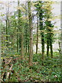
Coniferous woodland on the edge of Lemarnedown Plantation
Image: © Rod Allday
Taken: 30 Oct 2016
0.19 miles
6
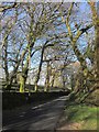
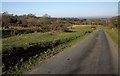
Lane to Stonaford
The no through lane from Tresellern, seen from the same spot as Image], running through trees that form a western extension of Old Plantation.
Image: © Derek Harper
Taken: 14 Apr 2015
0.21 miles