IMAGES TAKEN NEAR TO
North Hill, LAUNCESTON, PL15 7NR
Introduction
This page details the photographs taken nearby to PL15 7NR by members of the Geograph project.
The Geograph project started in 2005 with the aim of publishing, organising and preserving representative images for every square kilometre of Great Britain, Ireland and the Isle of Man.

There are currently over 7.5m images from over14,400 individuals and you can help contribute to the project by visiting https://www.geograph.org.uk
Image Map (Loading...)


Getting Data...Please wait
Leaflet Map data © OpenStreetMap
Images are licensed for reuse under creativecommons.org/licenses/by-sa/2.0
Notes
- Clicking on the map will re-center to the selected point.
- The higher the marker number, the further away the image location is from the centre of the postcode.
Image Listing (7 Images Found)
Images are licensed for reuse under creativecommons.org/licenses/by-sa/2.0
Image
Details
Distance
1
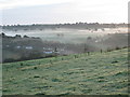
Uphill from Botternell
View over Bathpool Lane and the buildings on the outskirts of Bathpool looking towards Uphill.
Image: © Ken Ripper
Taken: 4 Oct 2010
0.06 miles
2
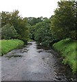
The River Lynher, Bathpool
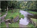
Taken from the north parapet of the Image], this is the view upstream on the River Lynher at Bathpool. (see also Image] & Image])
Image: © Rob Farrow
Taken: 14 Aug 2007
0.18 miles
3
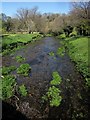
River Lynher at Bathpool
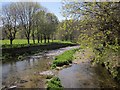
Looking upstream from Bathpool Bridge, like Image, which shows a rather higher water level, in spite of the season in which it was taken; Image] looks downstream.
Image: © Derek Harper
Taken: 20 Apr 2015
0.18 miles
4
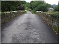
Bridge over the Lynher, Bathpool
This bridge allows access to Bathpool from the western side of the River Lynher.
For views from on or near this bridge, see Image], Image] & Image]
Image: © Rob Farrow
Taken: 14 Aug 2007
0.20 miles
5
By the Lynher, Bathpool
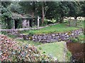
Taken from by the bridge over the River Lynher on the western edge of the village of Bathpool. Some kind of slipway into the river can be seen here (see Image]), with an old stone building behind. It was perhaps a loading point for goods from the nearby mill. A public footpath is seen heading off beside the river, but looking at the map it doesn't seem to go very far.
Image: © Rob Farrow
Taken: 14 Aug 2007
0.20 miles
6
Bathpool, Slipway into the Lynher
I'm calling this slope down into the River Lynher at Bathpool a "slipway" for want of a better description. Perhaps it was used for loading goods onto boats, or perhaps for launching small boats - or even perhaps it was the entry to a ford before the bridge was built. See also Image]
Image: © Rob Farrow
Taken: 14 Aug 2007
0.21 miles
7
River Lynher at Bathpool
Looking downstream from Bathpool Bridge.
Image: © Derek Harper
Taken: 20 Apr 2015
0.21 miles