IMAGES TAKEN NEAR TO
Penhole Close, LAUNCESTON, PL15 7NQ
Introduction
This page details the photographs taken nearby to Penhole Close, PL15 7NQ by members of the Geograph project.
The Geograph project started in 2005 with the aim of publishing, organising and preserving representative images for every square kilometre of Great Britain, Ireland and the Isle of Man.

There are currently over 7.5m images from over14,400 individuals and you can help contribute to the project by visiting https://www.geograph.org.uk
Image Map (Loading...)


Getting Data...Please wait
Leaflet Map data © OpenStreetMap
Images are licensed for reuse under creativecommons.org/licenses/by-sa/2.0
Notes
- Clicking on the map will re-center to the selected point.
- The higher the marker number, the further away the image location is from the centre of the postcode.
Image Listing (7 Images Found)
Images are licensed for reuse under creativecommons.org/licenses/by-sa/2.0
Image
Details
Distance
1
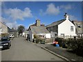
Coad's Green
The lane through the centre of the village.
Image: © Derek Harper
Taken: 4 Mar 2015
0.07 miles
2
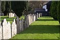
Gravestones, Coad's Green
A line of stones across the churchyard of Coads Green Methodist Church.
Image: © Derek Harper
Taken: 18 Oct 2007
0.09 miles
3
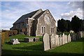
Coad's Green Methodist Church
The C19 church is listed http://list.english-heritage.org.uk/resultsingle.aspx?uid=1249977&searchtype=mapsearch . I think it dates from around 1848.
Image: © Derek Harper
Taken: 18 Oct 2007
0.10 miles
4
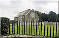
Wesleyan Methodist Church, Coad's Green
Image: © Paul Barnett
Taken: 1 Jan 2018
0.10 miles
5
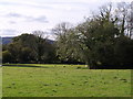
Field near Coad's Green
Sheep graze in an L-shaped meadow (the inward angle is on the right) beside the B3257 immediately north of Coad's Green, which lies on the watershed between the Inny and Lynher. In the far corner of the field rises a headwater of a tributary of the Lynher.
Image: © Derek Harper
Taken: 18 Oct 2007
0.14 miles
6
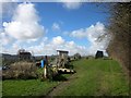
Allotments, Coad's Green
From the lane to Newtown. There are 12 plots here.
Image: © Derek Harper
Taken: 4 Mar 2015
0.22 miles
7
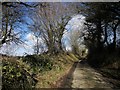
Lane near Coad's Green
The lane to Newtown seen from the same place as Image
Image: © Derek Harper
Taken: 4 Mar 2015
0.24 miles