IMAGES TAKEN NEAR TO
Middlewood, North Hill, LAUNCESTON, PL15 7NN
Introduction
This page details the photographs taken nearby to PL15 7NN by members of the Geograph project.
The Geograph project started in 2005 with the aim of publishing, organising and preserving representative images for every square kilometre of Great Britain, Ireland and the Isle of Man.

There are currently over 7.5m images from over14,400 individuals and you can help contribute to the project by visiting https://www.geograph.org.uk
Image Map (Loading...)


Getting Data...Please wait
Leaflet Map data © OpenStreetMap
Images are licensed for reuse under creativecommons.org/licenses/by-sa/2.0
Notes
- Clicking on the map will re-center to the selected point.
- The higher the marker number, the further away the image location is from the centre of the postcode.
Image Listing (8 Images Found)
Images are licensed for reuse under creativecommons.org/licenses/by-sa/2.0
Image
Details
Distance
1
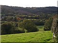
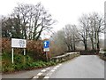
Lynher valley at Middlewood
Looking across the valley from the lane on the northeastern side between Bathpool and Berriowbridge. On this side the more gentle slopes are pasture; the steeper southwestern slopes, which rise towards Bodmin Moor, are more wooded, with much smaller fields. All the fields are thickly lined with hedgerow trees, increasing the wooded impression. On the left are buildings at the edge of the hamlet of Middletown.
Image: © Derek Harper
Taken: 18 Oct 2007
0.06 miles
3
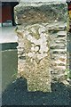
Old Milestone by Berrio Bridge House, North Hill
Carved stone post in parish of North Hill (North Cornwall District), Berrio Bridge House B & B, at end of boundary wall. Ornamental, on South side of road. C&L railway marker, erected by a railway company in the 19th century.
Inscription reads:-
2
M
Cornwall & Scilly HER.
HER Number: MCO58216 https://www.heritagegateway.org.uk/Gateway/Results_Single.aspx?uid=MCO58216&resourceID=1020
Milestone Society National ID: CW_M2
Image: © Bronwen Parr
Taken: 1 Jul 2006
0.18 miles
4
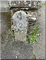
Old Milestone by Berrio Bridge House, North Hill
Carved stone post in parish of North Hill (North Cornwall District), Berrio Bridge House B & B, at end of boundary wall. Ornamental, on South side of road. C&L railway marker, erected by a railway company in the 19th century.
Inscription reads:-
2
M
Cornwall & Scilly HER.
HER Number: MCO58216 https://www.heritagegateway.org.uk/Gateway/Results_Single.aspx?uid=MCO58216&resourceID=1020
Milestone Society National ID: CW_M2
Image: © Mark Alice
Taken: 20 Aug 2024
0.18 miles
6
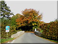
Beriow Bridge over the River Lynher
A Scheduled Monument and also Grade II* Listed. Dating from circa mid C16, repaired in 1640 (datestone) and widened on the upper side in 1890.
Image: © Rod Allday
Taken: 30 Oct 2016
0.22 miles
7
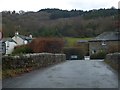
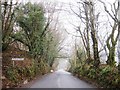
Berriowbridge in the Lynher valley
Several roads converge on the river to use this bridge
Image: © David Smith
Taken: 20 Mar 2013
0.23 miles
8
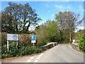
Berriow Bridge
Over the River Lynher.
Image: © Des Blenkinsopp
Taken: 30 Apr 2015
0.23 miles