IMAGES TAKEN NEAR TO
North Hill, LAUNCESTON, PL15 7NJ
Introduction
This page details the photographs taken nearby to PL15 7NJ by members of the Geograph project.
The Geograph project started in 2005 with the aim of publishing, organising and preserving representative images for every square kilometre of Great Britain, Ireland and the Isle of Man.

There are currently over 7.5m images from over14,400 individuals and you can help contribute to the project by visiting https://www.geograph.org.uk
Image Map
Images are licensed for reuse under creativecommons.org/licenses/by-sa/2.0
Notes
- Clicking on the map will re-center to the selected point.
- The higher the marker number, the further away the image location is from the centre of the postcode.
Image Listing (6 Images Found)
Images are licensed for reuse under creativecommons.org/licenses/by-sa/2.0
Image
Details
Distance
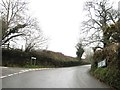
2
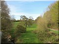
The Lynher valley
The B3254 descending into the valley at Berrowbridge. The valley is wooded Image on the edge of Bodmin Moor
Image: © David Smith
Taken: 20 Mar 2013
0.11 miles
3
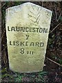
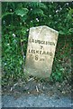
Old Milestone by the B3254, north of Berriowbridge
Carved stone post by the B3254, in parish of NORTH HILL (NORTH CORNWALL District), 160m North of East Berriow, in Cornish hedge on steep narrow descent, on East side of road. Liskeard iii stone, erected by the Local Highways Board in the 19th century.
Inscription reads:-
LAUNCESTON
7
LISKEARD
8iii
Grade II listed.
List Entry Number: 1249711 https://historicengland.org.uk/listing/the-list/list-entry/1249711
Milestone Society National ID: CW_LALK07.
Image: © Rosy Hanns
Taken: 24 Mar 2019
0.14 miles
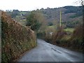
4
Lane to North Hill
Passing a track to the left down to Battens Mill on the Lynher.
Image: © Derek Harper
Taken: 20 Apr 2015
0.14 miles
5
Old Milestone by the B3254, north of Berriowbridge
Carved stone post by the B3254, in parish of NORTH HILL (NORTH CORNWALL District), 160m North of East Berriow, in Cornish hedge on steep narrow descent, on East side of road. Liskeard iii stone, erected by the Local Highways Board in the 19th century.
Inscription reads:-
LAUNCESTON
7
LISKEARD
8iii
Grade II Listed. List Entry Number: 1249711
https://historicengland.org.uk/listing/the-list/list-entry/1249711
Milestone Society National ID: CW_LALK07.
Image: © Ian Thompson
Taken: 1 May 2001
0.14 miles
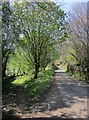
6
Beside the River Lynher
Fields north of Berriow Bridge.
Image: © Des Blenkinsopp
Taken: 30 Apr 2015
0.24 miles