IMAGES TAKEN NEAR TO
South Petherwin, LAUNCESTON, PL15 7JT
Introduction
This page details the photographs taken nearby to PL15 7JT by members of the Geograph project.
The Geograph project started in 2005 with the aim of publishing, organising and preserving representative images for every square kilometre of Great Britain, Ireland and the Isle of Man.

There are currently over 7.5m images from over14,400 individuals and you can help contribute to the project by visiting https://www.geograph.org.uk
Image Map (Loading...)


Getting Data...Please wait
Leaflet Map data © OpenStreetMap
Images are licensed for reuse under creativecommons.org/licenses/by-sa/2.0
Notes
- Clicking on the map will re-center to the selected point.
- The higher the marker number, the further away the image location is from the centre of the postcode.
Image Listing (3 Images Found)
Images are licensed for reuse under creativecommons.org/licenses/by-sa/2.0
Image
Details
Distance
1
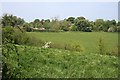
Looking towards Trelinnoe
Grass fields give way to the trees surrounding Trelinnoe.
Image: © Tony Atkin
Taken: 5 May 2007
0.04 miles
3
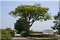
The Eastern Road
Leaving South Petherwin by the road to the east. There is a public house in a large detached building just outside this shot to the right but I thought that this tree was the more photogenic.
Image: © Tony Atkin
Taken: 5 May 2007
0.22 miles