IMAGES TAKEN NEAR TO
Tregaller Lane, LAUNCESTON, PL15 7JJ
Introduction
This page details the photographs taken nearby to Tregaller Lane, PL15 7JJ by members of the Geograph project.
The Geograph project started in 2005 with the aim of publishing, organising and preserving representative images for every square kilometre of Great Britain, Ireland and the Isle of Man.

There are currently over 7.5m images from over14,400 individuals and you can help contribute to the project by visiting https://www.geograph.org.uk
Image Map
Images are licensed for reuse under creativecommons.org/licenses/by-sa/2.0
Notes
- Clicking on the map will re-center to the selected point.
- The higher the marker number, the further away the image location is from the centre of the postcode.
Image Listing (1 Images Found)
Images are licensed for reuse under creativecommons.org/licenses/by-sa/2.0
Image
Details
Distance
1
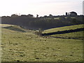
Valley near South Petherwin
The stream in the valley is a tributary of Lowley Brook. The glint on the grass is of dew. On reaching West Petherwin Wood, the stream meets another and bends to the left. The tower is of Image
Image: © Derek Harper
Taken: 18 Oct 2007
0.15 miles