IMAGES TAKEN NEAR TO
Pennygillam, LAUNCESTON, PL15 7EE
Introduction
This page details the photographs taken nearby to PL15 7EE by members of the Geograph project.
The Geograph project started in 2005 with the aim of publishing, organising and preserving representative images for every square kilometre of Great Britain, Ireland and the Isle of Man.

There are currently over 7.5m images from over14,400 individuals and you can help contribute to the project by visiting https://www.geograph.org.uk
Image Map (Loading...)


Getting Data...Please wait
Leaflet Map data © OpenStreetMap
Images are licensed for reuse under creativecommons.org/licenses/by-sa/2.0
Notes
- Clicking on the map will re-center to the selected point.
- The higher the marker number, the further away the image location is from the centre of the postcode.
Image Listing (14 Images Found)
Images are licensed for reuse under creativecommons.org/licenses/by-sa/2.0
Image
Details
Distance
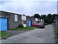
2
Ford car dealership Pennygillam Way, Launceston
Image: © Steve Fareham
Taken: 17 Oct 2013
0.09 miles
3
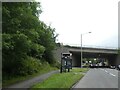
Bus shelter and A30 bridge over Western Road, Launceston
Image: © David Smith
Taken: 6 Jul 2021
0.11 miles
4
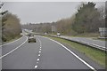
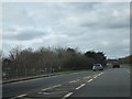
North Cornwall : The A30
The A30 heading nearby Launceston and onwards through Cornwall.
Image: © Lewis Clarke
Taken: 23 Feb 2014
0.12 miles
5
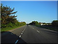
Slip road from A388 joining A30 westbound
The slip road joins the A30 immediately above the A388; the bridge parapet is on the left.
Image: © David Smith
Taken: 6 Mar 2012
0.13 miles
6
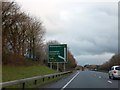
A30 eastbound exit for Launceston
The Pennygillam junction on the A30 leads to Launceston, the coastal area of Bude and west Devon around Holsworthy
Image: © David Smith
Taken: 18 Jan 2014
0.15 miles
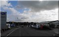
8
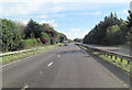
A30 north of Pennygillam Industrial Estate
Image: © Stuart Logan
Taken: 14 Oct 2012
0.17 miles
9

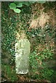
Old Milestone by the B3254, south of Launceston
Carved stone post by the B3254, in parish of LAUNCESTON (NORTH CORNWALL District), near recycling centre, in niche in rock cutting, on South side of road. Launceston pillar, erected by the Launceston turnpike trust in the 18th century.
Inscription reads:-
L
J
(Launceston 1 mile)
Grade II listed.
List Entry Number: 1392043 https://historicengland.org.uk/listing/the-list/list-entry/1392043
Milestone Society National ID: CW_LALK01.
Image: © Rosy Hanns
Taken: 29 Mar 2019
0.18 miles
10
Old Milestone by the B3254, south of Launceston
Carved stone post by the B3254, in parish of LAUNCESTON (NORTH CORNWALL District), near recycling centre, in niche in rock cutting, on South side of road. Launceston pillar, erected by the Launceston turnpike trust in the 18th century.
Inscription reads:-
L
J
Grade II Listed. List Entry Number: 1392043
https://historicengland.org.uk/listing/the-list/list-entry/1392043
Milestone Society National ID: CW_LALK01.
Image: © Ian Thompson
Taken: 1 Aug 2000
0.18 miles