IMAGES TAKEN NEAR TO
LAUNCESTON, PL15 0BX
Introduction
This page details the photographs taken nearby to PL15 0BX by members of the Geograph project.
The Geograph project started in 2005 with the aim of publishing, organising and preserving representative images for every square kilometre of Great Britain, Ireland and the Isle of Man.

There are currently over 7.5m images from over14,400 individuals and you can help contribute to the project by visiting https://www.geograph.org.uk
Image Map
Images are licensed for reuse under creativecommons.org/licenses/by-sa/2.0
Notes
- Clicking on the map will re-center to the selected point.
- The higher the marker number, the further away the image location is from the centre of the postcode.
Image Listing (9 Images Found)
Images are licensed for reuse under creativecommons.org/licenses/by-sa/2.0
Image
Details
Distance
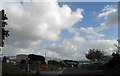
3
North Cornwall : The A30
The A30 road heading through North Cornwall.
Image: © Lewis Clarke
Taken: 24 Mar 2013
0.16 miles

5

Launceston Industrial Park
The extensive industrial area just south of Launceston continues to attract units.
Image: © Richard Knights
Taken: Unknown
0.18 miles
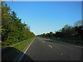
6
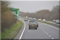
North Cornwall : The A30
The A30 heading through Cornwall.
Image: © Lewis Clarke
Taken: 23 Feb 2014
0.19 miles
7
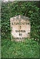
Old Milestone by the former A30 in Launceston
Carved stone post by the UC road (was A30), in parish of LAUNCESTON (NORTH CORNWALL District), Tresmarrow Road, by "Holme Park", follow signs for cemetery, against hedge, on North side of road. Launceston gravestone, erected by the Local Highways Board in the 19th century.
Inscription reads:-
LAUNCESTON
1
BODMIN
21
CAMELFORD
15
Grade II Listed. List Entry Number: 1392042
https://historicengland.org.uk/listing/the-list/list-entry/1392042
Milestone Society National ID: CW_BMLA21.
Image: © Ian Thompson
Taken: 1 May 2005
0.21 miles
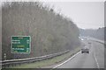
8
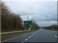
Advance sign for Pennygillam junction on A30
At the end of the on-slip from Tregadillett, on the eastbound A30, this sign gives advance warning of the main exit for Launceston. The sign partially conceals an "Emergency Sign Store"
Image: © David Smith
Taken: 18 Jan 2014
0.21 miles
9
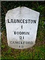
Old Milestone by the former A30, near Launceston cemetery
Carved stone post by the UC road (was A30), in parish of LAUNCESTON (NORTH CORNWALL District), Tresmarrow Road, by "Holme Park", follow signs for Cemetery, against hedge, on North side of road. Launceston gravestone, erected by the Local Highways Board in the 19th century.
Inscription reads:-
LAUNCESTON
1
BODMIN
21
CAMELFORD
15
Grade II listed.
List Entry Number: 1392042 https://historicengland.org.uk/listing/the-list/list-entry/1392042
Milestone Society National ID: CW_BMLA21.
Image: © Rosy Hanns
Taken: 29 Mar 2019
0.21 miles