IMAGES TAKEN NEAR TO
PLYMOUTH, PL1 4QZ
Introduction
This page details the photographs taken nearby to PL1 4QZ by members of the Geograph project.
The Geograph project started in 2005 with the aim of publishing, organising and preserving representative images for every square kilometre of Great Britain, Ireland and the Isle of Man.

There are currently over 7.5m images from over14,400 individuals and you can help contribute to the project by visiting https://www.geograph.org.uk
Image Map (Loading...)


Getting Data...Please wait
Leaflet Map data © OpenStreetMap
Images are licensed for reuse under creativecommons.org/licenses/by-sa/2.0
Notes
- Clicking on the map will re-center to the selected point.
- The higher the marker number, the further away the image location is from the centre of the postcode.
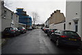
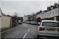
Image Listing (185 Images Found)
Images are licensed for reuse under creativecommons.org/licenses/by-sa/2.0
Image
Details
Distance
5
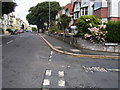
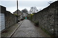
Passing Waterloo Street
Devonport Road passing Waterloo Street
Image: © Shaun Ferguson
Taken: 7 Aug 2010
0.03 miles
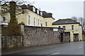
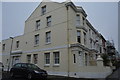
6
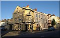
The Admiral Stopford
The pub is on the corner of Devonport Road and Stopford Place (left). Admiral Sir Robert Stopford's career is described at http://en.wikipedia.org/wiki/Robert_Stopford_(Royal_Navy_officer) .
Image: © Derek Harper
Taken: 9 Feb 2010
0.04 miles