IMAGES TAKEN NEAR TO
St. Neot, LISKEARD, PL14 6PP
Introduction
This page details the photographs taken nearby to PL14 6PP by members of the Geograph project.
The Geograph project started in 2005 with the aim of publishing, organising and preserving representative images for every square kilometre of Great Britain, Ireland and the Isle of Man.

There are currently over 7.5m images from over14,400 individuals and you can help contribute to the project by visiting https://www.geograph.org.uk
Image Map (Loading...)


Getting Data...Please wait
Leaflet Map data © OpenStreetMap
Images are licensed for reuse under creativecommons.org/licenses/by-sa/2.0
Notes
- Clicking on the map will re-center to the selected point.
- The higher the marker number, the further away the image location is from the centre of the postcode.
Image Listing (5 Images Found)
Images are licensed for reuse under creativecommons.org/licenses/by-sa/2.0
Image
Details
Distance
1
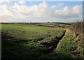
Field near Tredinnick
From the lane near Tredarrup Farm. After 120 metres, the field crosses into Image On the left is Tredinnick Methodist Chapel, with Great Tredinnick's wind turbine, installed in 2013, to the right.
Image: © Derek Harper
Taken: 24 Jan 2015
0.04 miles
2
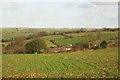
Tredarrup Farm
From the lane east of Tredinnick Methodist Chapel. The distinctive bending track by the field boundaries beyond is in Image
Image: © Derek Harper
Taken: 24 Jan 2015
0.05 miles
3

Animal graveyard, Tredarrup
Among the animals commemorated are Toby, Thumper and Misty. This is by the lane between Goonzion Downs and Tredinnick Methodist Chapel.
Image: © Derek Harper
Taken: 24 Jan 2015
0.09 miles
4
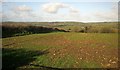
Field near Tredarrup Farm
From the same gateway as Image], looking to the left.
Image: © Derek Harper
Taken: 24 Jan 2015
0.14 miles
5
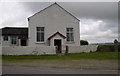
Tredinnick Methodist Chapel
On a bend in the road in a fairly remote area. Has an old cross next to it.
Image: © JEZ NORGAN
Taken: 14 Aug 2012
0.24 miles