IMAGES TAKEN NEAR TO
Beneathway Lane, LISKEARD, PL14 6JU
Introduction
This page details the photographs taken nearby to Beneathway Lane, PL14 6JU by members of the Geograph project.
The Geograph project started in 2005 with the aim of publishing, organising and preserving representative images for every square kilometre of Great Britain, Ireland and the Isle of Man.

There are currently over 7.5m images from over14,400 individuals and you can help contribute to the project by visiting https://www.geograph.org.uk
Image Map
Images are licensed for reuse under creativecommons.org/licenses/by-sa/2.0
Notes
- Clicking on the map will re-center to the selected point.
- The higher the marker number, the further away the image location is from the centre of the postcode.
Image Listing (20 Images Found)
Images are licensed for reuse under creativecommons.org/licenses/by-sa/2.0
Image
Details
Distance
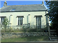
4
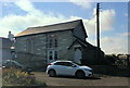
Disused telephone exchange at Dobwalls
West of the village on the (soon to be bypassed) A38. Note the vegetable patch in front of the small building.
Image: © Jonathan Billinger
Taken: 1 Apr 2008
0.14 miles
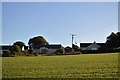
8
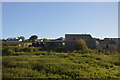
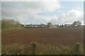
Farmland near Dobwalls
Pasture on the edge of the village.
Image: © Burgess Von Thunen
Taken: 29 Feb 2012
0.18 miles
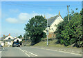
10
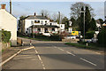
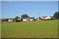
The Highwayman Pub
Dobwalls now bypassed and much quieter these days.
Image: © roger geach
Taken: 25 Nov 2011
0.20 miles