IMAGES TAKEN NEAR TO
LISKEARD, PL14 6HF
Introduction
This page details the photographs taken nearby to PL14 6HF by members of the Geograph project.
The Geograph project started in 2005 with the aim of publishing, organising and preserving representative images for every square kilometre of Great Britain, Ireland and the Isle of Man.

There are currently over 7.5m images from over14,400 individuals and you can help contribute to the project by visiting https://www.geograph.org.uk
Image Map
Images are licensed for reuse under creativecommons.org/licenses/by-sa/2.0
Notes
- Clicking on the map will re-center to the selected point.
- The higher the marker number, the further away the image location is from the centre of the postcode.
Image Listing (5 Images Found)
Images are licensed for reuse under creativecommons.org/licenses/by-sa/2.0
Image
Details
Distance
1
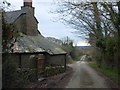
Higher Trengale farm
The road passes between the farmhouse and farm buildings
Image: © David Smith
Taken: 20 Mar 2013
0.06 miles
2
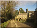
Higher Trengale Farm
A reverse view of Image The small cottage was "probably originally the farmhouse at Higher Trengale, now only one room surviving. Mid C17 with later alterations" http://list.english-heritage.org.uk/resultsingle.aspx?uid=1159355&searchtype=mapsearch . The farmhouse itself is next door.
Image: © Derek Harper
Taken: 24 Jan 2015
0.08 miles
4
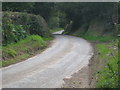
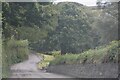
St Cleer : Country Lane
A small lane heads through the Cornish countryside.
Image: © Lewis Clarke
Taken: 26 Sep 2022
0.25 miles
5
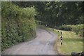
St Cleer : Country Lane
A small lane heads through the countryside.
Image: © Lewis Clarke
Taken: 26 Sep 2022
0.25 miles