IMAGES TAKEN NEAR TO
Pensilva Industrial Estate, St. Ive Road, LISKEARD, PL14 5RE
Introduction
This page details the photographs taken nearby to Pensilva Industrial Estate, St. Ive Road, PL14 5RE by members of the Geograph project.
The Geograph project started in 2005 with the aim of publishing, organising and preserving representative images for every square kilometre of Great Britain, Ireland and the Isle of Man.

There are currently over 7.5m images from over14,400 individuals and you can help contribute to the project by visiting https://www.geograph.org.uk
Image Map (Loading...)


Getting Data...Please wait
Leaflet Map data © OpenStreetMap
Images are licensed for reuse under creativecommons.org/licenses/by-sa/2.0
Notes
- Clicking on the map will re-center to the selected point.
- The higher the marker number, the further away the image location is from the centre of the postcode.
Image Listing (4 Images Found)
Images are licensed for reuse under creativecommons.org/licenses/by-sa/2.0
Image
Details
Distance
1
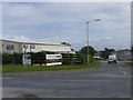
Pensilva Industrial Estate (East Entrance)
The entrance to the Eastern half of the Pensilva Industrial Estate, on the road to St. Ive.
Image: © Eric Foster
Taken: 19 Aug 2011
0.02 miles
2
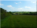
Pensilva - Footpath in Field near Cobwebs
Wind Turbine in the distance.
Image: © James Emmans
Taken: 26 May 2016
0.22 miles
4
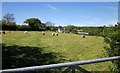
Sheep at Charaton
From the lane between Gang and Charaton Cross. Charaton Farm is in the background.
Image: © Derek Harper
Taken: 14 May 2014
0.24 miles