IMAGES TAKEN NEAR TO
St. Ive Road, LISKEARD, PL14 5RB
Introduction
This page details the photographs taken nearby to St. Ive Road, PL14 5RB by members of the Geograph project.
The Geograph project started in 2005 with the aim of publishing, organising and preserving representative images for every square kilometre of Great Britain, Ireland and the Isle of Man.

There are currently over 7.5m images from over14,400 individuals and you can help contribute to the project by visiting https://www.geograph.org.uk
Image Map (Loading...)


Getting Data...Please wait
Leaflet Map data © OpenStreetMap
Images are licensed for reuse under creativecommons.org/licenses/by-sa/2.0
Notes
- Clicking on the map will re-center to the selected point.
- The higher the marker number, the further away the image location is from the centre of the postcode.
Image Listing (20 Images Found)
Images are licensed for reuse under creativecommons.org/licenses/by-sa/2.0
Image
Details
Distance
1
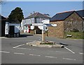
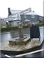
Pensilva Crossroads
This is the crossroads at the eastern end of Pensilva village. The fingerpost at the centre of the crossroads is mounted on a granite post.
Image: © Tony Atkin
Taken: 24 Mar 2007
0.10 miles
2
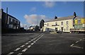
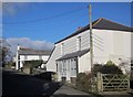
Cottages, Pensilva
Eastleigh is a pair of mid-Victorian cottages by Pensilva Cross at the east end of the village. This scene shows what tremendous views there are from Pensilva. The cast iron signpost dates from about 1900.
Image: © Derek Harper
Taken: 13 Dec 2014
0.10 miles
3
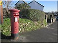
Postbox, Pensilva
Elizabeth II postbox number PL14 64D is at Pensilva Cross and can be seen in Image That looks like a Cornish hedge.
Image: © Derek Harper
Taken: 13 Dec 2014
0.12 miles
4
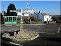
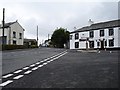
Pensilva Cross
On a granite column and base, the cast iron signpost dates from about 1900.
Image: © Derek Harper
Taken: 13 Dec 2014
0.12 miles
5
Old Direction Sign - Signpost by Victoria Inn, Pensilva
No finial - Granite post and fingers by the UC road, in parish of St Ive (Caradon District), by Victoria Inn, Pensilva, centre of road junction.
Cornwall & Scilly HER.
HER Number: MCO55537 https://www.heritagegateway.org.uk/Gateway/Results_Single.aspx?uid=MCO55537&resourceID=1020
Surveyed
Milestone Society National ID: CW_SX2969
Image: © Milestone Society
Taken: Unknown
0.12 miles
6
Pensilva Cross
On the right behind the signpost (see Image]) is the Victoria Inn. Image shows a similar view from eight years earlier, revealing the change in decoration of the pub, and the replacement of the building on the left.
Image: © Derek Harper
Taken: 13 Dec 2014
0.13 miles
7
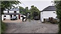
Victoria Inn, Pensilva
Showing something of the extraordinary width of this oblique crossroads where Golberdon Road (behind), Slade Park Road (right), Princess Road (ahead), Gooseberry Lane (left) and St Ive Road (continuation of Princess Road to the left and behind) meet.
Image: © Penny Mayes
Taken: 27 Jun 2006
0.14 miles
9
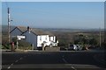
Slade Park Road, Pensilva
A view from Pensilva Cross. The road leads to Caradon Town.
Image: © Derek Harper
Taken: 13 Dec 2014
0.15 miles
10
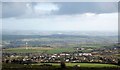
Pensilva from Caradon Hill
Taken from a little south of the television station on the summit. That'll be the wind turbine shown in Image
Image: © Derek Harper
Taken: 13 Dec 2014
0.19 miles